Lingig

Lingig
Municipality of Lingig
Lage von Lingig in der Provinz Surigao del Sur
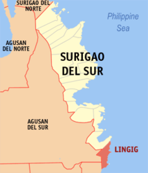
Karte
Basisdaten
Bezirk: Caraga
Provinz: Surigao del Sur
Barangays: 18
Distrikt: 2. Distrikt von Surigao del Sur
PSGC: 166812000
Einkommensklasse: 4. Einkommensklasse
Haushalte: 4954
Zensus 1. Mai 2000
Einwohnerzahl: 23.714
Zensus 1. August 2007
Koordinaten: 8° 2′ N, 126° 25′ O8.0333333333333126.41666666667Koordinaten: 8° 2′ N, 126° 25′ O
Postleitzahl: 8312
Bürgermeister: Roberto M. Luna Jr.
Offizielle Webpräsenz: www.lingig.gov.ph
Geographische Lage auf den Philippinen
Lingig (Philippinen)
Lingig
Lingig

Lingig ist eine philippinische Stadtgemeinde in der Provinz Surigao del Sur. Nach dem Zensus vom 1. Mai 2000 hat sie 26.487 Einwohner in 4954 Haushalten.

Baranggays

Lingig ist politisch in 18 Baranggays unterteilt.

  • Anibongan
  • Barcelona
  • Bogak
  • Bongan
  • Handamayan
  • Mahayahay
  • Mandus
  • Mansa-ilao
  • Pagtila-an
  • Palo Alto
  • Poblacion
  • Rajah Cabungso-an
  • Sabang
  • Salvacion
  • San Roque
  • Tagpoporan
  • Union
  • Valencia

Wikimedia Foundation.

Игры ⚽ Нужно решить контрольную?

Schlagen Sie auch in anderen Wörterbüchern nach:

  • Lingig — Original name in latin Lingig Name in other language Lingig State code PH Continent/City Asia/Manila longitude 8.03889 latitude 126.4125 altitude 8 Population 6400 Date 2011 07 31 …   Cities with a population over 1000 database

  • Lingig, Surigao del Sur — Lingig is a 3rd class municipality in the province of Surigao del Sur, Philippines. According to the 2000 census, it has a population of 26,487 people in 4,954 households.BarangaysLingig is politically subdivided into 18 barangays. * Anibongan *… …   Wikipedia

  • Bislig City — Lage von Bislig in der Provinz Surigao del Sur Basisdaten Bezirk …   Deutsch Wikipedia

  • PH-SUR — Lage der Provinz Surigao del Sur Surigao del Sur ist die 56. Provinz des Inselstaates der Philippinen. Sie befindet sich an der nordöstlichen Küste der Insel Mindanao und gehört politisch dem Regierungsbezirk Caraga (Region XIII) an. Der Sitz der …   Deutsch Wikipedia

  • Surigao del Sur — Infobox Philippine province name = Surigao del Sur sealfile = Ph seal surigao del sur.png region = Caraga (Region XIII) capital = Tandag City founded = pop2000 = 501,808 pop2000rank = 49th largest popden2000 = 110 popden2000rank = 15th lowest… …   Wikipedia

  • List of islands of the Philippines — This is a list of islands of the Philippines. There are 7,107 islands, of which about 4,000 are inhabited. They are clustered into the island groups of Luzon, Visayas, and Mindanao.Luzon**Batanes Islands ***Batan Island ***Diadekey Island… …   Wikipedia

  • Languages of the Philippines — See also: Philippine languages Languages of the Philippines Map of the dominant ethnolinguistic groups of the Philippines …   Wikipedia

  • Kamayo language — Kamayo is a minor language spoken in the area of Bislig City and also in San Agustin and Marihatag, Surigao del Sur, in the Southern Philippines. It has 7,565 speakers (2000, WCD). The dialect known as kamayo varies from one municipality to… …   Wikipedia

  • Cortes, Surigao del Sur — Map of Surigao del Sur showing the location of Cortes Cortes is a 4th class municipality in the province of Surigao del Sur, Philippines. According to the 2000 Philippine census, it has a population of 14,825 people in 2,742 households. Contents …   Wikipedia

  • Madrid, Surigao del Sur — Map of Surigao del Sur showing the location of Madrid Madrid is a 4th class municipality in the province of Surigao del Sur, Philippines. Madrid was named after the capital city of Spain, Madrid. It has 14 barangay s and two comprising the… …   Wikipedia

Share the article and excerpts

Direct link
Do a right-click on the link above
and select “Copy Link”