- Madrid (Surigao del Sur)
-
Municipality of Madrid Lage von Madrid in der Provinz Surigao del Sur Basisdaten Bezirk: Caraga Provinz: Surigao del Sur Barangays: 14 Distrikt: 1. Distrikt von Surigao del Sur PSGC: 166813000 Einkommensklasse: 4. Einkommensklasse Haushalte: 2862 Zensus 1. Mai 2000Einwohnerzahl: 14.957 Zensus 1. August 2007Koordinaten: 9° 16′ N, 125° 58′ O9.2666666666667125.96666666667Koordinaten: 9° 16′ N, 125° 58′ O Postleitzahl: 8316 Bürgermeister: Jose Arizobal Arpilleda Geographische Lage auf den Philippinen Madrid ist eine philippinische Stadtgemeinde in der Provinz Surigao del Sur. Nach dem Zensus vom 1. Mai 2000 hat sie 14.066 Einwohner in 2862 Haushalten.
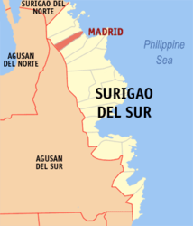
Baranggays
Madrid ist politisch in 14 Baranggays unterteilt.
- Bagsac
- Bayogo
- Linibonan
- Magsaysay
- Manga
- Panayogon
- Patong Patong
- Quirino (Pob.)
- San Antonio
- San Juan
- San Roque
- San Vicente
- Songkit
- Union
Städte und Stadtgemeinden in der Provinz Surigao del SurStädte: Bislig City | Tandag City
Stadtgemeinden: Barobo | Bayabas | Cagwait | Cantilan | Carmen | Carrascal | Cortes | Hinatuan | Lanuza | Lianga | Lingig | Madrid | Marihatag | San Agustin | San Miguel | Tagbina | Tago (Surigao del Sur)
Wikimedia Foundation.
Schlagen Sie auch in anderen Wörterbüchern nach:
Madrid, Surigao del Sur — Map of Surigao del Sur showing the location of Madrid Madrid is a 4th class municipality in the province of Surigao del Sur, Philippines. Madrid was named after the capital city of Spain, Madrid. It has 14 barangay s and two comprising the… … Wikipedia
Surigao del Sur — Localisation de la province de Surigao del Sur (en rouge) dans les Philippines. Administration Pays … Wikipédia en Français
Surigao del Sur — Lage der Provinz Surigao del Sur Surigao del Sur ist die 56. Provinz des Inselstaates der Philippinen. Sie befindet sich an der nordöstlichen Küste der Insel Mindanao und gehört politisch dem Regierungsbezirk Caraga (Region XIII) an. Der Sitz der … Deutsch Wikipedia
Surigao del Sur — Infobox Philippine province name = Surigao del Sur sealfile = Ph seal surigao del sur.png region = Caraga (Region XIII) capital = Tandag City founded = pop2000 = 501,808 pop2000rank = 49th largest popden2000 = 110 popden2000rank = 15th lowest… … Wikipedia
Carmen (Surigao del Sur) — Municipality of Carmen Lage von Carmen in der Provinz Surigao del Sur Basisdaten Bezirk … Deutsch Wikipedia
Cortes (Surigao del Sur) — Municipality of Cortes Lage von Cortes in der Provinz Surigao del Sur Basisdaten Bezirk … Deutsch Wikipedia
Cortes, Surigao del Sur — Map of Surigao del Sur showing the location of Cortes Cortes is a 4th class municipality in the province of Surigao del Sur, Philippines. According to the 2000 Philippine census, it has a population of 14,825 people in 2,742 households. Contents … Wikipedia
Lanuza, Surigao del Sur — Lanuza is a 4th class municipality in the province of Surigao del Sur, Philippines. It has a total land area of 395.76 km², representing 8.7% to the total area of Surigao del Sur. According to the 2000 census, it has a population of 10,057 people … Wikipedia
Marihatag, Surigao del Sur — Map of Surigao del Sur showing the location of Marihatag Marihatag is a 4th class municipality in the province of Surigao del Sur, Philippines. According to the 2000 census, it has a population of 16,394 people in 2,857 households. The current… … Wikipedia
Cantilan, Surigao del Sur — [http://www.cantilan.gov.ph/ Cantilan] is a 4th class municipality in the province of Surigao del Sur, Philippines. According to the 2000 census, it has a population of 26,553 people in 5,378 households.Cantilan is considered the Cradle of Towns… … Wikipedia