- Misool
-
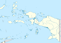
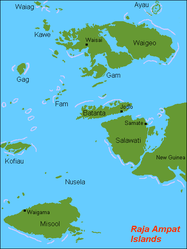
Misool Gewässer Pazifischer Ozean Inselgruppe Raja Ampat Geographische Lage 1° 54′ 0″ S, 130° 5′ 0″ O-1.9130.08333333333565Koordinaten: 1° 54′ 0″ S, 130° 5′ 0″ O Fläche 2.034 km² Höchste Erhebung 565 m Hauptort Waigama Raja-Ampat-Inseln mit Misool im Südwesten Misool (auch Misoöl) ist eine der vier Hauptinseln der Raja Ampat-Inselgruppe vor West-Neuguinea (Indonesien). Misool liegt in der Seramsee, südwestlich von der Vogelkopf-Halbinsel und hat eine Fläche (je nach Quelle) von 2034 km² bis 2041 km², die höchste Erhebung ist 565 m hoch. Salawati, Batanta und Waigeo bilden die anderen drei Hauptinseln der Inselgruppe.
Weblinks
Kategorien:- West Papua
- Insel (Indonesien)
- Insel (Australien und Ozeanien)
- Insel (Pazifischer Ozean)
- Papua Barat
Wikimedia Foundation.


