Motiti Island

Motiti Island

Vorlage:Infobox Insel/Wartung/Höhe fehlt

Motiti Island
Luftbild Motiti Island
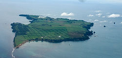
Gewässer Bay of Plenty (Südpazifik)
Geographische Lage 37° 37′ 32,52″ S, 176° 25′ 19,56″ O-37.6257176.4221Koordinaten: 37° 37′ 32,52″ S, 176° 25′ 19,56″ O
Motiti Island (Neuseeland)
Motiti Island
Fläche 10 km²

Motiti Island ist eine Insel in der Bay of Plenty an der Nordinsel Neuseelands. Sie liegt 21 km nordöstlich von Tauranga und 9,4 km nordöstlich von Papamoa.

Die relativ flache Insel ist 10 km² groß. Die Insel war beim Zensus von 1961 von 61 Einwohnern, davon 42 Maori und 19 Europäern, bewohnt. Haupterwerbszweig ist die Landwirtschaft.

Die Insel wurde am 2. November 1769 von James Cook als erstem Europäer entdeckt.

Weblinks


Wikimedia Foundation.

Игры ⚽ Нужно сделать НИР?

Schlagen Sie auch in anderen Wörterbüchern nach:

  • Motiti Island — Maori: Motiti An aerial view of Motiti Island. Geography Location …   Wikipedia

  • Wairoa Stream, Motiti Island — A small stream called the Wairoa Stream is found on Motiti Island in the Bay of Plenty, New Zealand …   Wikipedia

  • Isla Motiti — Vista aérea de la Isla Motiti. La Isla Motiti está localizada en la Bahía de la Abundancia (Bay of Plenty) en la Isla del Norte en Nueva Zelanda. A 21 kilómetros al noreste de Tauranga y 9.4km al noereste de Papamoa. De acuerdo con el censo de… …   Wikipedia Español

  • Île Motiti — 37° 37′ 33″ S 176° 25′ 20″ E / 37.6257, 176.4221 …   Wikipédia en Français

  • Ngātoro-i-rangi — In Māori tradition, Ngātoro i rangi (Ngātoro) is the name of a tohunga (priest) prominent during the settling of Aotearoa (New Zealand) by the Māori people, who came from the mythical homeland Hawaiki. Contents 1 Rangiātea 2 Journey to Aotearoa 3 …   Wikipedia

  • Distrikte Neuseelands — Karte der neuseeländischen Distrikte und Regionen Distrikte (engl.: Territorial Authority) bilden die zweite Stufe der Verwaltungsgliederung Neuseelands. Die erste Stufe bilden die 16 Regionen (17 mit dem Council der Chatham Inseln). Insgesamt… …   Deutsch Wikipedia

  • Territorial Authority — Karte der neuseeländischen Distrikte und Regionen Distrikte (engl.: Territorial Authority) bilden die zweite Stufe der Verwaltungsgliederung Neuseelands. Die erste Stufe bilden die 16 Regionen (17 mit dem Council der Chatham Inseln). Insgesamt… …   Deutsch Wikipedia

  • Metrosideros excelsa — Eisenholzbaum Metrosideros excelsa Systematik Klasse: Dreifurchenpollen Zweikeimblättrige (Rosopsida) …   Deutsch Wikipedia

  • Pohutukawa — Eisenholzbaum Metrosideros excelsa Systematik Klasse: Dreifurchenpollen Zweikeimblättrige (Rosopsida) …   Deutsch Wikipedia

  • List of islands of New Zealand — New Zealand consists of a large number of islands. The two main islands, which are much larger than the rest and where most of the population lives, are the North Island and the South Island. The latter is often a little ironically referred to as …   Wikipedia

Share the article and excerpts

Direct link
Do a right-click on the link above
and select “Copy Link”