- Mount Amak
-
Mount Amak 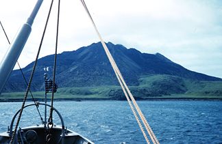
Amak Island
Höhe 488 m Lage Alaska (USA) Gebirge Aleutenkette Geographische Lage 55° 25′ 27″ N, 163° 8′ 57″ W55.424166666667-163.14916666667488Koordinaten: 55° 25′ 27″ N, 163° 8′ 57″ W 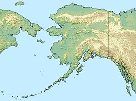

Typ Schichtvulkan Letzte Eruption 1796 Der Mount Amak ist ein 488 m hoher Schichtvulkan der Aleutenkette. Der Vulkan liegt nördlich der Alaska-Halbinsel in der Bristol Bay auf der Insel Amak. Es handelt sich um die östlichste der Aleuten-Inseln. Das Gesamtvolumen des Vulkans beträgt etwa 1 Kubikkilometer. Bei den Ausbrüchen von 1700-1710 sowie 1796 entstanden Blocklavaströme. Frühere Lavaströme, vermutlich vor 4.000 bis 5.000 Jahren entstanden, bestehen vorwiegend aus andesitischer Lava.
Weblinks
- Mount Amak im Global Volcanism Program der Smithsonian Institution (englisch)
Kategorien:- Berg unter 1000 Meter
- Schichtvulkan
- Berg in Alaska
- Berg in Nordamerika
- Berg in der Aleutenkette


Wikimedia Foundation.