Mount Katmai

Mount Katmai
Mount Katmai
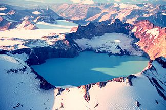
Mount Katmai mit Kratersee im Sept. 1980

Mount Katmai mit Kratersee im Sept. 1980

Höhe 2.047 m
Lage Alaska, USA
Gebirge Alëutenkette
Geographische Lage 58° 16′ 43″ N, 154° 57′ 25″ W58.278611111111-154.956916666672047Koordinaten: 58° 16′ 43″ N, 154° 57′ 25″ W
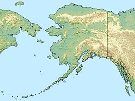
Mount Katmai (Alaska)
Mount Katmai
Typ Stratovulkan

Der Mount Katmai – auch Katmai – ist ein Stratovulkan auf der Alaska-Halbinsel im Südwesten Alaskas im Katmai-Nationalpark gelegen. Er liegt in der Alëutenkette und ist somit ein Teil des Feuerrings um den Pazifik. Der Kraterrand erreicht eine Höhe von 2047 m. Der Vulkan hat einen Durchmesser von 10 km. In seinem Zentrum befindet sich eine 3-4,5 km breite Caldera, in der sich ein knapp 250 m tiefer Kratersee auf einer Höhe von 1286 m gebildet hat. Der Katmai ist vergletschert.

Historische Ausbrüche des Katmai sind nicht bekannt. In 10 km Entfernung kam es jedoch im Juni 1912 zu einem heftigen Vulkanausbruch des Novarupta. In Folge dieses Ausbruches brach die unter dem Gipfel des Katmai gelegene Lavakammer ein. Es entstand die heute noch mit Wasser gefüllte Caldera.

Literatur

  • Charles Arthur Wood, Jürgen Kienle: Volcanoes of North America : The United States and Canada. Cambridge University Press, 1990 ISBN 978-0-521-43811-7

Weblinks

 Commons: Mount Katmai – Sammlung von Bildern, Videos und Audiodateien

Wikimedia Foundation.

Игры ⚽ Нужно решить контрольную?

Schlagen Sie auch in anderen Wörterbüchern nach:

  • Mount Katmai —   [ maʊnt kætmaɪ], Vulkan in Alaska, USA, auf der Alaskahalbinsel, 2 047 m über dem Meeresspiegel; der Kraterrand ist vergletschert. Bei dem gewaltigen Ausbruch von 1912 wurde ein grünes Tal in das »Tal der zehntausend Dämpfe« verwandelt, in dem… …   Universal-Lexikon

  • Mount Katmai — This article is about Katmai, the volcano. For other meanings see Katmai (disambiguation). Mount Katmai Mount Katmai and its crater lake in September 1980 …   Wikipedia

  • Mount Katmai — Mont Katmai Pour les articles homonymes, voir Katmai. Mont Katmai Vue aérienne de la caldeira du mont Katmai en 1980 …   Wikipédia en Français

  • USS Mount Katmai (AE-16) — was laid down 11 November 1944 by North Carolina Shipbuilding Co., Wilmington, N.C.; launched 6 January 1945; sponsored by Mrs. A. E. DeMaray; and commissioned 21 July 1945 at Jacksonville, Fla., Comdr. C. H. Ross in command.After shakedown and… …   Wikipedia

  • Katmai National Park — Katmai Nationalpark Braunbär in der Hallo Bay …   Deutsch Wikipedia

  • Katmai National Park and Preserve — Katmai Nationalpark Braunbär in der Hallo Bay …   Deutsch Wikipedia

  • Mount Griggs — NW view from west rim of Katmai caldera, July 1990 Elevation 7,602 ft (2,317 m)  …   Wikipedia

  • Mount Griggs — Ansicht aus Nordwesten (vom Mount Katmai aus) Höhe 2.317& …   Deutsch Wikipedia

  • Katmai — can mean:*Katmai National Park and Preserve a park in Alaska *Mount Katmai a volcano in the Katmai Park in Alaska; the site of a colossal 1912 eruption *Katmai Pentium III computer microprocessor core *USS Mount Katmai (AE 16) an ammunition ship… …   Wikipedia

  • Mount Mageik — (left) and Mount Martin (right) Elevation 7,103 ft (2,165 m) …   Wikipedia

Share the article and excerpts

Direct link
Do a right-click on the link above
and select “Copy Link”