Mount Popa

Mount Popa
Mount Popa
Mount Popa.JPG
Höhe 1.518 m
Lage Myanmar
Geographische Lage 20° 55′ 19″ N, 95° 14′ 56″ O20.92194444444495.2488888888891518Koordinaten: 20° 55′ 19″ N, 95° 14′ 56″ O
Mount Popa (Myanmar)
Mount Popa
Typ Schichtvulkan
Letzte Eruption 442 v. Chr.
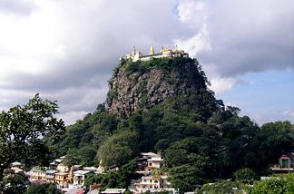
Kloster auf dem Taung Kalat

Kloster auf dem Taung Kalat

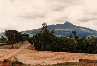
Der Mount Popa ist ein erloschener Vulkan in der Myingyan-Ebene in Zentralmyanmar, etwa 50 km südöstlich der Tempelstadt Bagan in der Mandalay-Division.

Bei einem gewaltigen Erdbeben 442 v. Chr. schob sich der Mount Popa etwa 1.000 m aus der Ebene. Die Höhe über dem Meeresspiegel beträgt 1.518 m. Die fruchtbare Vulkanerde inmitten der öden Umgebung brachte unzählige Blumen in allen Farben hervor. Vom Sanskrit-Wort für 'Blume' (Popa) erhielt der Berg seinen Namen.

Gelegentlich wird auch der 737 m hohe, südwestlich gelegene Vulkankegel Taung Kalat als Mount Popa bezeichnet. Auf dem Gipfel befindet sich die Tuyin Taung-Pagode. An und auf der hinaufführenden, überdachten Treppe leben viele Affen, die sich von den Gaben der Besucher ernähren.

Mount Popa gilt als Wohnstätte der Nats, die die Schutzheiligen Myanmars darstellen.

Bilder

Weblinks

 Commons: Mount Popa – Sammlung von Bildern, Videos und Audiodateien

Wikimedia Foundation.

Игры ⚽ Нужен реферат?

Schlagen Sie auch in anderen Wörterbüchern nach:

  • Mount Popa — Elevation 1,518 m (4,980 ft) …   Wikipedia

  • Mount Popa Pipistrelle — Conservation status Least Concern (IUCN 3.1) Scientific classification …   Wikipedia

  • Popa — bezeichnet: Mount Popa, Vulkan in Myanmar Popafälle in Namibia Popa spurca, eine Fangschrecke Popa ist der Familienname folgender Personen: Adrián Popa (* 1971), ungarischer Gewichtheber Alexandru Popa (* 1968), rumänischer Kanurennsportler… …   Deutsch Wikipedia

  • Popa Mountain Resort Mandalay (Mandalay) — Popa Mountain Resort Mandalay country: Myanmar, city: Mandalay (Mount Popa) Popa Mountain Resort Mandalay Set amidst the towering mountains and lush greeneries, the Popa Mountain Resort is located in the city of Mandalay and is 45 minutes away… …   International hotels

  • Popa, Mount —    Located about midway between Pagan (Bagan) and Meiktila in Mandalay Division, what is popularly known as Mount Popa is actually the core of an extinct volcano, rising 737 meters (2,200 feet) above the Myingyan Plain. It is the site of shrines… …   Historical Dictionary of Burma (Myanmar)

  • Popa Hill — ▪ volcano, Myanmar also called  Mount Popa    extinct volcano, central Myanmar (Burma), at the northern end of the Pegu Mountains (Bago Mountains). It rises to 4,981 feet (1,518 m), has a mile wide crater, and is the highest point in the range.… …   Universalium

  • Mount Victoria National Park — IUCN Category II (National Park) Location Chin State,  …   Wikipedia

  • Mont Popa — Vue du mont Popa et du Taung Kalat sur la gauche. Géographie Altitude 1 518 m Massif Aucun Coord …   Wikipédia en Français

  • Battles and operations of the Indian National Army — The Battles and Operations involving the Indian National Army during World War II were all fought in the South East Asian theatre. These range from the earliest deployments of the INA s preceding units in espionage during Malayan Campaign in 1942 …   Wikipedia

  • Nat (spirit) — Nat oun (Suxorimus) hung on a post in a house. The nats (Burmese: နတ်‌; MLCTS: nat; …   Wikipedia

Share the article and excerpts

Direct link
Do a right-click on the link above
and select “Copy Link”