- Mandalay-Division
-
2195.75Koordinaten: 21° N, 96° O
မ္ဝန္ပ္ရည္နယ္
Mandalay-Division
Hauptstadt Mandalay Fläche 37.023 km² Bevölkerung 7.627.000[1] Ethnien Birmanen,Karen,
Chinesen, Inder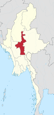
Die Mandalay-Division ist eine der 14 Verwaltungseinheiten von Myanmar.
Geographie
Die Mandalay-Division grenzt im Norden an die Sagaing-Division, im Osten an den Shan-Staat und im Süden an den Kayin-Staat und die Bago-Division. Im Westen grenzt sie an die Magwe-Division. Die Hauptstadt der Mandalay-Division ist die gleichnamige Stadt Mandalay. Im Süden der Mandalay-Division liegt die neue Hauptstadt Myanmars, Naypyidaw, im Distrikt Pyinmana.
Wirtschaft
Die Mandalay-Division ist eine der wichtigsten Regionen von Myanmar. Landwirtschaft spielt die größte Rolle, besonders der Anbau von Reis, Mais, Weizen, Sesam, Baumwolle, Tabak, Chili, Zuckerrohr und Gemüse. Des Weiteren befinden sich Textilfabriken, Zucker- und Reismühlen und Edelsteinminen im Gebiet der Division. Der Tourismus spielt auch eine immer größere Rolle, zumal neben der alten Königsstadt Mandalay einige wichtige historische Stätten wie Ava, Amarapura und Bagan, sowie die touristisch interessanten Ziele Mount Popa und die Stadt Pyin U Lwin auf dem Gebiet der Mandalay-Division liegen.
Quellen
Schlagen Sie auch in anderen Wörterbüchern nach:
Mandalay Division — Infobox Burmesestatedivision englishname = Mandalay Division burmesename = မန္တလေးတိုင်း transcription = manta.le: tuing: capital = Mandalay region = Central area = 37,023 population = 6,442,000 locatormapfile = MyanmarMandalay ethnic = Bamar,… … Wikipedia
Mandalay Division — One of Burma s 14 states and divisions, with an area of 37,946 square kilometers (14,651 square miles) and an estimated population in 2000 of 6.76 million (1983 census figure: 4,577,762). The divisional capital is Mandalay, which was Burma s… … Historical Dictionary of Burma (Myanmar)
Myittha, Mandalay Division — Infobox Settlement official name = Myittha other name = native name = nickname = settlement type = motto = imagesize = image caption = flag size = image seal size = image shield = shield size = image blank emblem = blank emblem type = blank… … Wikipedia
Thazi, Meiktila, Mandalay Division — Infobox Settlement official name = Thazi other name = native name = nickname = settlement type = motto = imagesize = image caption = flag size = image seal size = image shield = shield size = image blank emblem = blank emblem type = blank emblem… … Wikipedia
Tatkon, Mandalay Division — Infobox Settlement official name = Tatkon other name = native name = nickname = settlement type = motto = imagesize = image caption = flag size = image seal size = image shield = shield size = image blank emblem = blank emblem type = blank emblem … Wikipedia
Pyawbwe, Pyawbwe, Mandalay Division — Infobox Settlement official name = Pyawbwe other name = native name = nickname = settlement type = motto = imagesize = image caption = flag size = image seal size = image shield = shield size = image blank emblem = blank emblem type = blank… … Wikipedia
Pyawbwe, Myittha Township, Mandalay Division — Infobox Settlement official name = Pyawbwe other name = native name = nickname = settlement type = motto = imagesize = image caption = flag size = image seal size = image shield = shield size = image blank emblem = blank emblem type = blank… … Wikipedia
Mandalay Region — မန္တလေးတိုင်းဒေသကြီး Region Myanma transcription(s) … Wikipedia
Mandalay District — မန္တလေး ခရိုင် District of Mandalay Division Mandalay District … Wikipedia
Mandalay Technological University — မန္တလေး နည်းပညာ တက္ကသိုလ် Established 1 October 1991 Type Public Students 2000 (2004) … Wikipedia
Mandalay-Division


18+
© Academic, 2000-2026
- Kontaktieren Sie uns: Unterstützung, Werbung
Wörterbücher Export, schritte mit PHP, Joomla, Drupal, WordPress, MODx.