- Mount Siple
-
Mount Siple 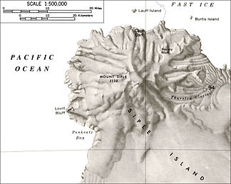
Topografische Karte vom Mount Siple
Höhe 3.110 m Lage Siple-Insel, Antarktis Dominanz 363 km → Mount Hampton Schartenhöhe 3.110 m Geographische Lage 73° 24′ 0″ S, 126° 42′ 0″ W-73.4-126.73110Koordinaten: 73° 24′ 0″ S, 126° 42′ 0″ W 

Typ Schildvulkan, gegenwärtig inaktiv Erstbesteigung unbestiegen 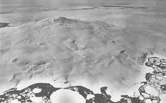
Luftaufnahme des Mount Siple
Der Mount Siple ist ein gegenwärtig inaktiver Schildvulkan in der Antarktis. Der 3.110 m hohe Vulkan ist ein ausgedehnter schneebedeckter Berg mit einem kegelförmigen Bau. Er dominiert den nordwestlichen Teil der Siple-Insel, die durch das Getz-Schelfeis von der Bakutis-Küste getrennt ist.
Der Berg trägt den Namen von Paul Allman Siple (1908 - 1968), einem US-amerikanischen Antarktisforscher und Geografen, der an sechs Antarktisexpeditionen teilnahm, unter anderem an den ersten beiden Expeditionen von Richard Evelyn Byrd zur Siple-Küste (1928 - 1930) und zur Siple-Insel (1933 - 1935). Der Berg wurde während eines Erkundungsfluges entdeckt, bei dem Siple als Navigator diente.
Weblinks
- Mount Siple im Global Volcanism Program der Smithsonian Institution (englisch)
- http://usarc.usgs.gov/
- http://www.skimountaineer.com/ROF/RingOfFire.html
- Mount Siple (Englisch). Geographic Names Information System. United States Geological Survey. Abgerufen am 26. Juli 2010.
Kategorien:- Dreitausender
- Schildvulkan
- Berg in Antarktika
- Unbestiegener Gipfel


Wikimedia Foundation.