- Mufumbwe
-
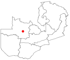 Geographische Lage von Mufumbwe
Mufumbwe, auch Chizera, ist ein Ort mit 6.155 Einwohnern (Schätzung 2006) in der Nordwestprovinz von Sambia 850 Kilometer nordwestlich von Lusaka und 225 Kilometer westlich von Solwezi. Er liegt 1.069 Meter über dem Meeresspiegel und ist Sitz der Verwaltung des gleichnamigen Distrikts mit 71.238 Einwohnern (Volkszählung 2000). Mit Kabompo, Mpika, Chinsali und Sesheke gehört der Distrikt mit weniger als vier Menschen pro Quadratkilometer zu den am dünnsten besiedelten in Sambia.
Inhaltsverzeichnis
Geschichte
Mufumbwe gehörte lange zum Distrikt vom 37 Kilometer entfernten Kasempa, was nach der Abtrennung einige Probleme aufwarf. So fehlen hier ein Krankenhaus, Ärzte und Banken. Es gibt eine Grundschule, aber noch keine Sekundarschule. Der gesamte Distrikt ist auf Kasempa angewiesen. In Mufumbwe gibt es Landminen. Sie wurden ab 1970 wurden aus Gründen des „Grenzschutzes“ vergraben und können immer noch explodieren.
Wirtschaft
Mufumbwe ist ein Distrikt, in dem Bohrlöcher, also die grundsätzlichste Form der Trinkwasserversorgung, im Mittelpunkt stehen. Die Versorgung mit Häusern pro Familie ist die geringste von ganz Sambia. Zu den Zeichen von Wohlstand gehören hier die Rinderherde und in begrenzterem Maße die Größe des bebauten Ackers. Das besagt nichts über die tatsächliche Ernährungsgrundlage, die überwiegend aus Wild, Mais, Kassava, Honig und Fisch besteht. Die Ernteerträge schwanken sehr, je nach Regenzeit zwischen 2.253 und 5.140 Tonnen für Mais.
Infrastruktur
Die Straßen im Distrikt sind Sandpisten. Der Distrikt verfügt über viel Miombowald.
Soziales
Der dominierende Stamm sind die Kaonde.
Siehe auch
- Karte mit allen Distrikten und Provinzen siehe: Verwaltungsgliederung Sambias
Schlagen Sie auch in anderen Wörterbüchern nach:
Mufumbwe — is a town of Mufumbwe District in the Northwestern Province of Zambia. It is located at 13°41 0S 24°48 0E with an altitude of 1069 metres (3510 feet).[1] References ^ … Wikipedia
Mufumbwe — Original name in latin Mufumbwe Name in other language State code ZM Continent/City Africa/Lusaka longitude 13.68333 latitude 24.8 altitude 1143 Population 6155 Date 2006 01 17 … Cities with a population over 1000 database
Mufumbwe District — District District location in Zambia Country … Wikipedia
District de Mufumbwe — Districts de Zambie Vue sur une carte de District de Mufumbwe Administration Pays … Wikipédia en Français
Districts of Zambia — Zambia This article is part of the series: Politics and government of Zambia President Michael Sata … Wikipedia
Liste der traditionellen Feste in Sambia — Dies ist die Liste der traditionellen Feste in Sambia: Provinz Häuptling Bezirk Stamm Zeremonie Monat ZENTRALPROVINZ Bisa/Swaka/Lala Chiefs Mkushi Bisa/Swaka/Lala Inchibwela Mushi September … Deutsch Wikipedia
Northwestern Province, Zambia — Location of North Western Province in Zambia Distric … Wikipedia
Copperbelt Province — Location of Copperbelt Province in Zambia Copperbelt Province in Zambia covers the mineral rich Copperbelt, and farming and bush areas to the south. It was the backbone of the Northern Rhodesian economy during British colonial rule and fuelled… … Wikipedia
Northern Province, Zambia — Northern Province is one of Zambia s nine provinces. It covers approximately one fifth of Zambia in land area. The provincial capital is Kasama. The province is made up of 12 districts, namely Kasama (the provincial capital), Chilubi, Isoka,… … Wikipedia
Mwinilunga — is a town in the North Western Province of Zambia and headquarters of a district of that name. It lies on the West Lunga River, not far from the borders with the Democratic Republic of the Congo and Angola. Contents 1 Overview … Wikipedia
Mufumbwe

18+
© Academic, 2000-2026
- Kontaktieren Sie uns: Unterstützung, Werbung
Wörterbücher Export, schritte mit PHP, Joomla, Drupal, WordPress, MODx.