- Navajo (New Mexico)
-
Navajo 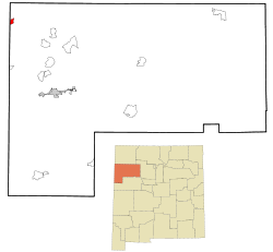 Lage in New Mexico
Basisdaten Staat: Vereinigte Staaten Bundesstaat: New Mexico County: Koordinaten: 35° 54′ N, 109° 2′ W35.905555555556-109.028611111112168Koordinaten: 35° 54′ N, 109° 2′ W Zeitzone: Mountain Standard Time (UTC−7) Einwohner: 2097 (Stand: 2000) Bevölkerungsdichte: 355,4 Einwohner je km² Fläche: 5,9 km² (ca. 2 mi²)
davon 5,9 km² (ca. 2 mi²) LandHöhe: 2168 m Postleitzahl: 87328 Vorwahl: +1 505 FIPS: 35-51420 GNIS-ID: 0933101 Navajo (Navajo:Ni'iijíhí) ist ein Dorf im Nordwesten des US-Bundesstaates New Mexico im McKinley County in der Navajo-Nation-Reservation.
Navajo liegt an der Grenze zum US-Bundesstaat Arizona am Red Lake. Es hat 2097 Einwohner, von denen 34,5 % arbeitslos sind [1]. Die Fläche beträgt 5,9 km². Die nächste große Stadt ist Gallup, etwa 50 Kilometer Luftlinie entfernt.
Anmerkung

Wikimedia Foundation.