Nuea Khlong

Nuea Khlong
Nuea Khlong
เหนือคลอง
Provinz: Krabi
Fläche: 414,8 km²
Einwohner: 54.789 (2005)
Bev.dichte: 132,1 E./km²
PLZ: 81130
Geocode: 8108
Karte
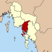
Karte von Krabi, Thailand mit Nuea Khlong

Amphoe Nuea Khlong (Thai: อำเภอ เหนือคลอง), ist ein Landkreis (Amphoe - Verwaltungs-Distrikt) der Provinz Krabi. Die Provinz Krabi liegt in der Südregion von Thailand.

Inhaltsverzeichnis

Geographie

Benachbarte Distrikte (von Nordwesten im Uhrzeigersinn): die Amphoe Mueang Krabi, Khao Phanom, Khlong Thom und Ko Lanta der Provinz Krabi. Im Westen liegt die Andamanensee.

Geschichte

Der Unterbezirk (King Amphoe) Nuea Khlong wurde am 13. März 1992 eingerichtet, indem acht Tambon vom Amphoe Mueang Krabi abgetrennt wurden. [1] Am 5. Dezember 1996 bekam der Landkreis seinen vollen Amphoe-Status. [2]

Verkehr

Im Amphoe Nuea Khlong liegt der internationale Flughafen Krabi, der die Provinz mit den restlichen Teilen des Landes sowie mit dem benachbarten Ausland verbindet.

Verwaltung

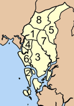
Amphoe Nuea Khlong ist in acht Gemeinden (Tambon) eingeteilt, welche wiederum in 56 Dorfgemeinschaften (Muban) unterteilt sind.

Nuea Khlong selbst hat einen Kleinstadt-Status (Thesaban Tambon), sie besteht aus Teilen des Tambon Nuea Khlong.

Jeder Tambon wird von einer Tambon Administrative Organization (TAO) verwaltet, welche für die Gebiete verantwortlich zeichnen, die nicht in den Städten organisiert sind.

Nr. Name Thai Muban Einw.     
1. Nuea Khlong เหนือคลอง 7 12.217
2. Ko Siboya เกาะศรีบอยา 7 4.643
3. Khlong Khanan คลองขนาน 9 7.999
4. Khlong Khamao คลองเขม้า 4 4.968
5. Khok Yang โคกยาง 7 5.835
6. Taling Chan ตลิ่งชัน 5 5.425
7. Pakasai ปกาสัย 9 7.192
8. Huai Yung ห้วยยูง 8 6.510
 Übersichtskarte der Tambon

Einzelnachweise

  1. ประกาศกระทรวงมหาดไทย เรื่อง แบ่งเขตท้องที่อำเภอเมืองกระบี่ จังหวัดกระบี่ ตั้งเป็นกิ่งอำเภอเหนือคลอง Royal Gazette, Bd. 109, Ausg. 53 ง ฉบับพิเศษ (spezial) vom 22. April 1992, S. 1 (in Thai)
  2. พระราชกฤษฎีกาตั้งอำเภอเหนือคลอง อำเภอนายายอาม อำเภอท่าตะเกียบ อำเภอขุนตาล อำเภอแม่ฟ้าหลวง อำเภอแม่ลาว อำเภอรัษฎา อำเภอพุทธมณฑล อำเภอวังน้ำเขียว อำเภอเจาะไอร้อง อำเภอชำนิ อำเภอโนนดินแดง อำเภอปางมะผ้า อำเภอสนธิ อำเภอหนองม่วง อำเภอเบญจลักษ์ อำเภอโพนนาแก้ว อำเภอบุ่งคล้า อำเภอดอนมดแดง และอำเภอลืออำนาจ พ.ศ. ๒๕๓๙ Royal Gazette, Bd. 113, Ausg. 62 ก vom 20. November 1996, S. 5-8 (in Thai)

Weblinks


8.074722222222299.0036111111117Koordinaten: 8° 4′ N, 99° 0′ O


Wikimedia Foundation.

Игры ⚽ Поможем сделать НИР

Schlagen Sie auch in anderen Wörterbüchern nach:

  • Nuea Khlong — 1 Original name in latin Nuea Khlong Name in other language Amphoe Nuea Khlong, Ban Nua Khlong, King Amphoe Nuea Khlong, Nuea Khlong, henux khlxng State code TH Continent/City Asia/Bangkok longitude 8.07144 latitude 98.99933 altitude 10… …   Cities with a population over 1000 database

  • Nuea Khlong District — Nuea Khlong เหนือคลอง   Amphoe   Amphoe location in Krabi Province …   Wikipedia

  • Amphoe Nuea Khlong — Nuea Khlong เหนือคลอง Provinz: Krabi Fläche: 414,8 km² Einwohner: 54.789 (2005) Bev.dichte: 132,1 E./km² PLZ: 81130 …   Deutsch Wikipedia

  • Amphoe Nuea Khlong — Infobox Amphoe thai=เหนือคลอง name=Nuea Khlong province=Krabi coordinates=coord|8|4|29|N|99|0|13|E|type:landmark region:TH capital=Nuea Khlong area=414.8 population=54,789 population as of=2548 density=132.1 postal code=81130 geocode=8108Nuea… …   Wikipedia

  • Amphoe Nuea Khlong — Admin ASC 2 Code Orig. name Amphoe Nuea Khlong Country and Admin Code TH.63.7511034 TH …   World countries Adminstrative division ASC I-II

  • Khlong Saen Saeb — (in Thai: คลองแสนแสบ, also known as Saen Saep) is a canal (Khlong) in central Thailand, connecting the Chao Phraya River to Prachin Buri and Chachoengsao. A portion of the canal is used for public transport by an express boat service in… …   Wikipedia

  • Amphoe Khlong Thom — Khlong Thom คลองท่อม Provinz: Krabi Fläche: 1042,53 km² Einwohner: 66.800 (2005) Bev.dichte: 61,1 E./km² PLZ: 81120 …   Deutsch Wikipedia

  • Khlong Saen Saep Express Boat — The Khlong Saen Saep Express Boat service operates on the Khlong Saen Saep in Bangkok, providing fast, inexpensive transportation through the city s traffic congested commercial districts. The service has a checkered reputation, due to the… …   Wikipedia

  • Khlong Yan Wildlife Sanctuary — Infobox protected area | name = Khlong Yan Wildlife Sanctuary iucn category = IV caption = locator x = locator y = location = Thailand nearest city = Surat Thani lat degrees = lat minutes = lat seconds = lat direction = long degrees = long… …   Wikipedia

  • Amphoe Khlong Thom — Infobox Amphoe name=Khlong Thom thai=คลองท่อม province=Krabi coordinates=coord|7|57|12|N|99|8|42|E|type:adm2nd region:TH area=1,042.531 population=66,800 population as of=2005 density=61.1 postal code=81120 geocode=8104Khlong Thom ( th. คลองท่อม) …   Wikipedia

Share the article and excerpts

Direct link
Do a right-click on the link above
and select “Copy Link”