- Old Panamao
-
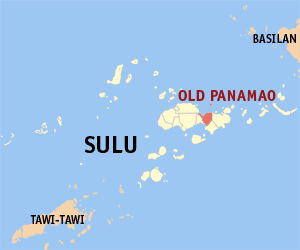
Municipality of Old Panamao Lage von Old Panamao in der Provinz Sulu 
Basisdaten Bezirk: Autonomous Region in Muslim Mindanao Provinz: Sulu Barangays: 31 Distrikt: 2. Distrikt von Sulu PSGC: 156607000 Einkommensklasse: 4. Einkommensklasse Haushalte: 5663 Zensus 1. Mai 2000Einwohnerzahl: 49.903 Zensus 1. August 2007Koordinaten: 5° 59′ N, 121° 15′ O5.9833333333333121.25Koordinaten: 5° 59′ N, 121° 15′ O Postleitzahl: 7402 Offizielle Webpräsenz: Old Panamao Geographische Lage auf den Philippinen 

Old Panamao Old Panamao ist eine philippinische Stadtgemeinde in der Provinz Sulu. Nach dem Zensus vom 1. Mai 2000 hat sie 35.906 Einwohner in 5663 Haushalten.
Baranggays
Old Panamao ist politisch in 31 Baranggays unterteilt.
- Asin
- Bakud
- Bangday
- Baunoh
- Bitanag
- Bud Seit
- Bulangsi
- Datag
- Kamalig
- Kan Asaali
- Kan Ukol
- Kan-Dayok
- Kan-Sipat
- Kawasan
- Kulay-kulay
- Lakit
- Lower Patibulan
- Lunggang
- Parang
- Pugad Manaul
- Puhagan
- Seit Higad
- Seit Lake (Pob.)
- Su-uh
- Tabu Manuk
- Tandu-tandu
- Tayungan
- Tinah
- Tubig Gantang
- Tubig Jati
- Upper Patibulan
Stadtgemeinden in der Provinz SuluStadtgemeinden: Hadji Panglima Tahil | Indanan | Jolo | Kalingalan Caluang | Lugus | Luuk | Maimbung | Old Panamao | Omar | Pandami | Panglima Estino | Pangutaran | Parang | Pata | Patikul | Siasi | Talipao | Tapul | Tongkil
Wikimedia Foundation.
Schlagen Sie auch in anderen Wörterbüchern nach:
Old Panamao, Sulu — Old Panamao is a 4th class municipality in the province of Sulu, Philippines. According to the 2007 census, it has a population of 49,903 people in 5,663 households. Barangays Old Panamao is politically subdivided into 31 barangays. Asin Bakud… … Wikipedia
Panglima Estino — Municipality of Panglima Estino (New Panamao) Lage von Panglima Estino (New Panamao) in der Provinz Sulu Basisdaten Bezir … Deutsch Wikipedia
PH-SLU — Lage der Inselprovinz Sulu Sulu ist eine Provinz der Philippinen. Sie besteht aus mehreren Inseln des Sulu Archipels und nimmt den äußersten Südwesten des Inselstaates zwischen Basilan und Tawi Tawi ein. Die Provinz gehört politisch dem Bezirk… … Deutsch Wikipedia
Sulu (Provinz) — Lage der Inselprovinz Sulu Sulu ist eine Provinz der Philippinen. Sie besteht aus mehreren Inseln des Sulu Archipels und nimmt den äußersten Südwesten des Inselstaates zwischen Basilan und Tawi Tawi ein. Die Provinz gehört politisch dem Bezirk… … Deutsch Wikipedia
Jolo — Infobox Islands name = Jolo image caption = Map of Sulu showing the location of Jolo locator Location map|Philippines|lat=5.983333|long=121.133333|width=175|float=center map custom = yes native name = Sulu native name link = location = South East … Wikipedia
Maimbung, Sulu — Maimbung is a 5th class municipality in the province of Sulu, Philippines. According to the 2000 census, it has a population of 24,982 people in 3,920 households. Barangays Maimbung is politically subdivided into 27 barangays. And Sultan as an… … Wikipedia
List of cities and municipalities in the Philippines — This is a list of cities and municipalities in the Philippines arranged by province and in alphabetical order. As of 2006, there are 118 cities and 1509 municipalities.As of September 4, 2007, there are 136 cities, 1,495 municipalities, 81… … Wikipedia
Legislative districts of Sulu — Philippines This article is part of the series: Politics and government of the Philippines … Wikipedia
Omar, Sulu — Omar is a municipality in the province of Sulu, Philippines. It was created out of the 8 barangays of Luuk, Sulu, by virtue of Muslim Mindanao Autonomy Act No. 194, which was subsequently ratified in a plebiscite held on July 18, 2007. Barangays… … Wikipedia
Hadji Panglima Tahil — Municipality of Hadji Panglima Tahil (Marunggas) Lage von Hadji Panglima Tahil (Marunggas) in der Provinz Sulu Basisdaten … Deutsch Wikipedia
Old Panamao

18+
© Academic, 2000-2026
- Kontaktieren Sie uns: Unterstützung, Werbung
Wörterbücher Export, schritte mit PHP, Joomla, Drupal, WordPress, MODx.