Kalingalan Caluang

Kalingalan Caluang
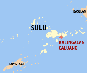
Municipality of Kalingalan Caluang
Lage von Kalingalan Caluang in der Provinz Sulu
Karte
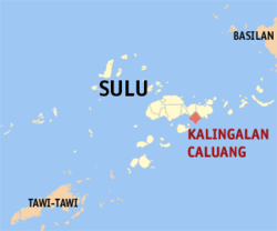
Basisdaten
Bezirk: Autonomous Region in Muslim Mindanao
Provinz: Sulu
Barangays: 9
Distrikt: 2. Distrikt von Sulu
PSGC: 101307000
Einkommensklasse: 5. Einkommensklasse
Haushalte: 4162
Zensus 1. Mai 2000
Einwohnerzahl: 36.557
Zensus 1. August 2007
Koordinaten: 5° 53′ N, 121° 16′ O5.8833333333333121.26666666667Koordinaten: 5° 53′ N, 121° 16′ O
Postleitzahl: 7416
Geographische Lage auf den Philippinen
Kalingalan Caluang (Philippinen)
Kalingalan Caluang
Kalingalan Caluang

Kalingalan Caluang ist eine philippinische Stadtgemeinde in der Provinz Sulu. Nach dem Zensus vom 1. Mai 2000 hat sie 22.688 Einwohner in 4162 Haushalten.

Baranggays

Kalingalan Caluang ist politisch in neun Baranggays unterteilt.

  • Kambing
  • Kanlagay
  • Karungdong (Pob.)
  • Masjid Bayle
  • Masjid Punjungan
  • Pang
  • Pangdan Pangdan
  • Pitogo
  • Tunggol

Wikimedia Foundation.

Игры ⚽ Поможем решить контрольную работу

Schlagen Sie auch in anderen Wörterbüchern nach:

  • Kalingalan Caluang, Sulu — Kalingalan Caluang is a 5th class municipality in the province of Sulu, Philippines. According to the 2000 census, it has a population of 22,688 people in 4,162 households.BarangaysKalingalan Caluang is politically subdivided into 9 barangays.*… …   Wikipedia

  • PH-SLU — Lage der Inselprovinz Sulu Sulu ist eine Provinz der Philippinen. Sie besteht aus mehreren Inseln des Sulu Archipels und nimmt den äußersten Südwesten des Inselstaates zwischen Basilan und Tawi Tawi ein. Die Provinz gehört politisch dem Bezirk… …   Deutsch Wikipedia

  • Jolo — Infobox Islands name = Jolo image caption = Map of Sulu showing the location of Jolo locator Location map|Philippines|lat=5.983333|long=121.133333|width=175|float=center map custom = yes native name = Sulu native name link = location = South East …   Wikipedia

  • Maimbung, Sulu — Maimbung is a 5th class municipality in the province of Sulu, Philippines. According to the 2000 census, it has a population of 24,982 people in 3,920 households. Barangays Maimbung is politically subdivided into 27 barangays. And Sultan as an… …   Wikipedia

  • Old Panamao, Sulu — Old Panamao is a 4th class municipality in the province of Sulu, Philippines. According to the 2007 census, it has a population of 49,903 people in 5,663 households. Barangays Old Panamao is politically subdivided into 31 barangays. Asin Bakud… …   Wikipedia

  • List of cities and municipalities in the Philippines — This is a list of cities and municipalities in the Philippines arranged by province and in alphabetical order. As of 2006, there are 118 cities and 1509 municipalities.As of September 4, 2007, there are 136 cities, 1,495 municipalities, 81… …   Wikipedia

  • Legislative districts of Sulu — Philippines This article is part of the series: Politics and government of the Philippines …   Wikipedia

  • Omar, Sulu — Omar is a municipality in the province of Sulu, Philippines. It was created out of the 8 barangays of Luuk, Sulu, by virtue of Muslim Mindanao Autonomy Act No. 194, which was subsequently ratified in a plebiscite held on July 18, 2007. Barangays… …   Wikipedia

  • Hadji Panglima Tahil — Municipality of Hadji Panglima Tahil (Marunggas) Lage von Hadji Panglima Tahil (Marunggas) in der Provinz Sulu Basisdaten …   Deutsch Wikipedia

  • Indanan — Municipality of Indanan Lage von Indanan in der Provinz Sulu Basisdaten Bezirk: Autonomous …   Deutsch Wikipedia

Share the article and excerpts

Direct link
Do a right-click on the link above
and select “Copy Link”