Pangutaran

Pangutaran
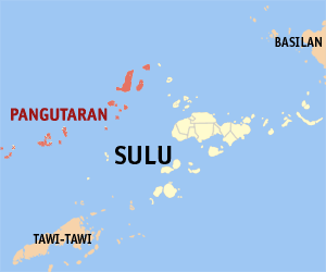
Municipality of Pangutaran
Lage von Pangutaran in der Provinz Sulu
Karte
Basisdaten
Bezirk: Autonomous Region in Muslim Mindanao
Provinz: Sulu
Barangays: 16
Distrikt: 1. Distrikt von Sulu
PSGC: 156608000
Einkommensklasse: 4. Einkommensklasse
Haushalte: 4643
Zensus 1. Mai 2000
Einwohnerzahl: 29.571
Zensus 1. August 2007
Koordinaten: 6° 18′ N, 120° 35′ O6.3120.58333333333Koordinaten: 6° 18′ N, 120° 35′ O
Postleitzahl: 7414
Offizielle Webpräsenz: Pangutaran
Geographische Lage auf den Philippinen
Pangutaran (Philippinen)
Pangutaran
Pangutaran

Pangutaran ist eine philippinische Stadtgemeinde in der Provinz Sulu und die Bezeichnung einer gleichnamigen Inselgruppe. Nach dem Zensus vom 1. Mai 2000 leben in der Provinz 26.211 Einwohner in 4.643 Haushalten.

Baranggays

Pangutaran ist politisch in 16 Baranggays unterteilt.

  • Alu Bunah
  • Bangkilay
  • Kawitan
  • Kehi Niog
  • Lantong Babag
  • Lumah Dapdap
  • Pandan Niog
  • Panducan
  • Panitikan
  • Patutol
  • Se-ipang
  • Simbahan (Pob.)
  • Suang Bunah
  • Tonggasang
  • Tubig Nonok
  • Tubig Sallang

Wikimedia Foundation.

Игры ⚽ Поможем написать курсовую

Schlagen Sie auch in anderen Wörterbüchern nach:

  • Pangutaran — Pangutaran, Insel im Suluarchipel, nordwestlich von Sulu …   Pierer's Universal-Lexikon

  • Pangutaran sama — Parlée en  Philippines Région Sulu Nombre de locuteurs 35 200 (en 2000)[1 …   Wikipédia en Français

  • Pangutaran, Sulu — Pangutaran is a 4th class municipality in the province of Sulu, Philippines. According to the 2000 census, it has a population of 26,211 people in 4,643 households.BarangaysPangutaran is politically subdivided into 16 barangays. * Alu Bunah *… …   Wikipedia

  • Pangutaran Sama — ISO 639 3 Code : slm ISO 639 2/B Code : ISO 639 2/T Code : ISO 639 1 Code : Scope : Individual Language Type : Living …   Names of Languages ISO 639-3

  • PH-SLU — Lage der Inselprovinz Sulu Sulu ist eine Provinz der Philippinen. Sie besteht aus mehreren Inseln des Sulu Archipels und nimmt den äußersten Südwesten des Inselstaates zwischen Basilan und Tawi Tawi ein. Die Provinz gehört politisch dem Bezirk… …   Deutsch Wikipedia

  • Sulu (Provinz) — Lage der Inselprovinz Sulu Sulu ist eine Provinz der Philippinen. Sie besteht aus mehreren Inseln des Sulu Archipels und nimmt den äußersten Südwesten des Inselstaates zwischen Basilan und Tawi Tawi ein. Die Provinz gehört politisch dem Bezirk… …   Deutsch Wikipedia

  • List of islands of the Philippines — This is a list of islands of the Philippines. There are 7,107 islands, of which about 4,000 are inhabited. They are clustered into the island groups of Luzon, Visayas, and Mindanao.Luzon**Batanes Islands ***Batan Island ***Diadekey Island… …   Wikipedia

  • Maimbung, Sulu — Maimbung is a 5th class municipality in the province of Sulu, Philippines. According to the 2000 census, it has a population of 24,982 people in 3,920 households. Barangays Maimbung is politically subdivided into 27 barangays. And Sultan as an… …   Wikipedia

  • Old Panamao, Sulu — Old Panamao is a 4th class municipality in the province of Sulu, Philippines. According to the 2007 census, it has a population of 49,903 people in 5,663 households. Barangays Old Panamao is politically subdivided into 31 barangays. Asin Bakud… …   Wikipedia

  • List of cities and municipalities in the Philippines — This is a list of cities and municipalities in the Philippines arranged by province and in alphabetical order. As of 2006, there are 118 cities and 1509 municipalities.As of September 4, 2007, there are 136 cities, 1,495 municipalities, 81… …   Wikipedia

Share the article and excerpts

Direct link
Do a right-click on the link above
and select “Copy Link”