Pata (Sulu)

Pata (Sulu)
Municipality of Pata
Lage von Pata in der Provinz Sulu
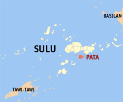
Karte
Basisdaten
Bezirk: Autonomous Region in Muslim Mindanao
Provinz: Sulu
Barangays: 14
Distrikt: 2. Distrikt von Sulu
PSGC: 156610000
Einkommensklasse: 5. Einkommensklasse
Haushalte: 2048
Zensus 1. Mai 2000
Einwohnerzahl: 20.095
Zensus 1. August 2007
Koordinaten: 5° 50′ N, 121° 5′ O5.8333333333333121.08333333333Koordinaten: 5° 50′ N, 121° 5′ O
Postleitzahl: 7405
Offizielle Webpräsenz: Pata
Geographische Lage auf den Philippinen
Pata (Philippinen)
Pata
Pata

Pata ist eine philippinische Stadtgemeinde in der Provinz Sulu. Nach dem Zensus vom 1. Mai 2000 hat sie 11.791 Einwohner in 2048 Haushalten.

Baranggays

Pata ist politisch in 14 Baranggays unterteilt.

  • Andalan
  • Daungdong
  • Kamawi
  • Kanjarang
  • Kayawan (Pob.)
  • Kiput
  • Likud
  • Luuk-tulay
  • Niog-niog
  • Patian
  • Pisak-pisak
  • Saimbangon
  • Sangkap
  • Timuddas

Wikimedia Foundation.

Игры ⚽ Поможем решить контрольную работу

Schlagen Sie auch in anderen Wörterbüchern nach:

  • Pata, Sulu — Pata is a 4th class municipality in the province of Sulu, Philippines. According to the 2000 census, it has a population of 11,791 people in 2,048 households.BarangaysPata is politically subdivided into 14 barangays.* Andalan * Daungdong * Kamawi …   Wikipedia

  • PATA — ist die Bezeichnung für: Pata (Slowakei), ein Dorf im Okres Galanta in der Slowakei; Pata (Sulu), eine Stadtgemeinde in der Provinz Sulu auf den Philippinen; Pata (Waffe), ein Kurzschwert aus Nordindien; Pata (Musiker) ist der Künstlername von… …   Deutsch Wikipedia

  • Pata — may refer to: Pata (weapon), an Indian weapon Pata (musician), a Japanese guitarist Pata, Sulu, a Philippine municipality Pata, a village in Apahida Commune, Cluj County, Romania Pata, Galanta District, a village in the Galanta District of… …   Wikipedia

  • Sulu-Archipel — Karte des Sulu Archipels Gewässer Pazifischer Ozean Geographisch …   Deutsch Wikipedia

  • Sulu (Provinz) — Lage der Inselprovinz Sulu Sulu ist eine Provinz der Philippinen. Sie besteht aus mehreren Inseln des Sulu Archipels und nimmt den äußersten Südwesten des Inselstaates zwischen Basilan und Tawi Tawi ein. Die Provinz gehört politisch dem Bezirk… …   Deutsch Wikipedia

  • Legislative districts of Sulu — Philippines This article is part of the series: Politics and government of the Philippines …   Wikipedia

  • Jolo (Sulu) — Municipality of Jolo Lage von Jolo in der Provinz Sulu Basisdaten Bezirk: Autonomous Region in Mu …   Deutsch Wikipedia

  • Omar, Sulu — Omar is a municipality in the province of Sulu, Philippines. It was created out of the 8 barangays of Luuk, Sulu, by virtue of Muslim Mindanao Autonomy Act No. 194, which was subsequently ratified in a plebiscite held on July 18, 2007. Barangays… …   Wikipedia

  • Parang (Sulu) — Municipality of Parang Lage von Parang in der Provinz Sulu Basisdaten Bezirk: Autonomous Regi …   Deutsch Wikipedia

  • Maimbung, Sulu — Maimbung is a 5th class municipality in the province of Sulu, Philippines. According to the 2000 census, it has a population of 24,982 people in 3,920 households. Barangays Maimbung is politically subdivided into 27 barangays. And Sultan as an… …   Wikipedia

Share the article and excerpts

Direct link
Do a right-click on the link above
and select “Copy Link”