Padre Island

Padre Island

Vorlage:Infobox Insel/Wartung/Fläche fehltVorlage:Infobox Insel/Wartung/Höhe fehlt

Padre Island
Sanddünen in der Padre Island National Seashore
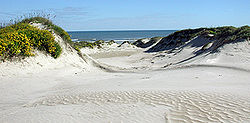
Gewässer
Geographische Lage 26° 50′ N, 97° 24′ W26.831666666667-97.402222222222Koordinaten: 26° 50′ N, 97° 24′ W
Padre Island (Texas)
Padre Island
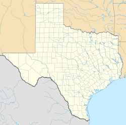
Länge 210 km
Breite 2,6 km

Padre Island ist eine Insel vor der Küste von Texas. Sie ist die weltweit längste Sanddünen-Insel. Benannt wurde die Insel nach Padre José Nicolás Ballí (177?–1829), der die erste Mission im Cameron County gründete.

Padre Island ist rund 210 Kilometer lang und erstreckt sich von Corpus Christi im Norden bis nach South Padre Island im Süden. Vom Festland ist sie durch die Laguna Madre getrennt. Durch eine Straße ist sie im Norden mit der Mustang Island verbunden. Im Suden verbindet der Queen Isabella Causeway (Texas State Route 100) mit Port Isabel auf dem Festland. Zwischen der Südspitze der Insel und der sich südlich anschließenden viel kleineren Halbinsel Brazos Island liegt der Brazos Santiago Pass.

Die Insel ist dünn besiedelt. Im Süden liegen die Gemeinden South Padre Island und Port Isabel. Im zentralen Teil liegt der Padre Island National Seashore. Seit 1964 ist die Insel zweigeteilt. Der künstliche Kanal Port Mansfield Channel trennt die Insel in die North Padre Island und die South Padre Island.

Weblinks

 Commons: Padre Island – Sammlung von Bildern, Videos und Audiodateien

Wikimedia Foundation.

Игры ⚽ Поможем сделать НИР

Schlagen Sie auch in anderen Wörterbüchern nach:

  • Padre Island — (the world s longest barrier island) is part of the U.S. state of Texas. The island is located on Texas southern coast of the Gulf of Mexico and is famous for its white sandy beaches at the south end. It is named after Padre José Nicolás Ballí (c …   Wikipedia

  • Padre Island — Île Padre Dunes de sable de Padre Island L Île Padre ou Padre Island est le banc de sable île le plus long du monde et est situé sur la côte de la région du Sud Texas. L île est ainsi nommée en référence au Padre Jose Nicolas Balli (vers 1770… …   Wikipédia en Français

  • Padre Island — Barrier island, southern Texas, U.S. It is 113 mi (182 km) long and up to 3 mi (5 km) wide, lying along the Gulf Coast of Texas. It extends south from Corpus Christi to Port Isabel and is separated from the mainland by Laguna Madre. It contains a …   Universalium

  • Padre Island — Sp Pãdrės salà Ap Padre Island L Meksikos įl., JAV (Teksasas) …   Pasaulio vietovardžiai. Internetinė duomenų bazė

  • Island Inn on The Beach - South Padre Island (Corpus Christi) — Island Inn on The Beach South Padre Island country: United States, city: Corpus Christi (South Padre Island) Island Inn on The Beach South Padre Island Location Island Inn on The Beach South Padre Island is located right on the beach and is only… …   International hotels

  • Island Inn South Padre Island — (Южный остров Падре,США) Категория отеля: 2 звездочный отель Адрес: 3813 …   Каталог отелей

  • Padre Island National Seashore — Dünenlandschaft …   Deutsch Wikipedia

  • Padre Island National Seashore — Infobox protected area | name = Padre Island National Seashore iucn category = V caption = locator x = 135 locator y = 167 location = Padre Island, Texas, USA nearest city = Corpus Christi, Texas lat degrees = 26 lat minutes = 59 lat seconds = 04 …   Wikipedia

  • Padre Island National Seashore — Sp Pãdrės Salõs nacionãlinis jūros krañtas Ap Padre Island National Seashore L gamtos rezervatas JAV (Teksasas) …   Pasaulio vietovardžiai. Internetinė duomenų bazė

  • Padre Island — geographical name island 113 miles (182 kilometers) long S Texas between Laguna Madre & Gulf of Mexico …   New Collegiate Dictionary

Share the article and excerpts

Direct link
Do a right-click on the link above
and select “Copy Link”