Padre Island National Seashore
- Padre Island National Seashore
-
| Padre Island National Seashore |
|
Dünenlandschaft |
|
|
| Lage: |
Texas, Vereinigte Staaten |
| Nächste Stadt: |
Corpus Christi |
| Fläche: |
528 km² km² |
| Gründung: |
28. September 1962 |
| Besucher: |
666.850 (2005) |
|
|
26.984444444444-97.368611111111
i3i6
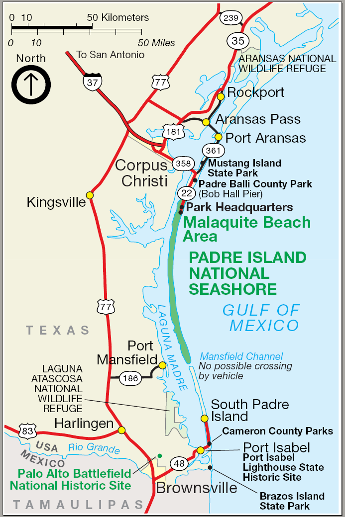
Padre Island National Seashore ist ein US-amerikanischer Nationalpark. Er umfasst einen langen Abschnitt des nördlichen Teils der Insel Padre Island an der Golfküste im US-Bundesstaat Texas.
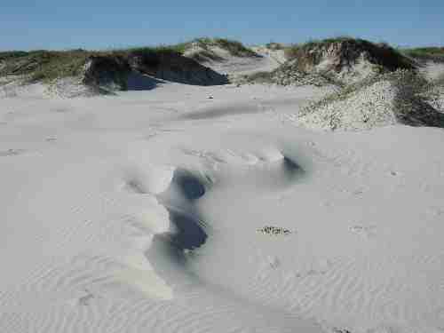
Der Park besteht aus größtenteils unberührter Küste und der dahinter liegenden Dünenlandschaft der schmalen Insel (Nehrung). Besonders interessant ist er für Naturliebhaber in der Zeit des Vogelzugs, da viele Zugvögel auf dem Weg über den Golf von Mexiko dort rasten. Der Küstenstreifen ist der längste unbebaute Strand der gesamten USA.
Weblinks
Wikimedia Foundation.
Schlagen Sie auch in anderen Wörterbüchern nach:
Padre Island National Seashore — Infobox protected area | name = Padre Island National Seashore iucn category = V caption = locator x = 135 locator y = 167 location = Padre Island, Texas, USA nearest city = Corpus Christi, Texas lat degrees = 26 lat minutes = 59 lat seconds = 04 … Wikipedia
Padre Island National Seashore — Sp Pãdrės Salõs nacionãlinis jūros krañtas Ap Padre Island National Seashore L gamtos rezervatas JAV (Teksasas) … Pasaulio vietovardžiai. Internetinė duomenų bazė
Cumberland Island National Seashore — IUCN Category II (National Park) … Wikipedia
Padre Island — (the world s longest barrier island) is part of the U.S. state of Texas. The island is located on Texas southern coast of the Gulf of Mexico and is famous for its white sandy beaches at the south end. It is named after Padre José Nicolás Ballí (c … Wikipedia
Padre Island — Vorlage:Infobox Insel/Wartung/Fläche fehltVorlage:Infobox Insel/Wartung/Höhe fehlt Padre Island Sanddünen … Deutsch Wikipedia
National Seashore — Inseln im Schutzgebiet Canaveral National Seashore Als National Seashore (engl. Nationale Meeresküste) werden an der Küste gelegene Schutzgebiete in den Vereinigten Staaten bezeichnet, die durch die Bundesregierung der Vereinigten Staaten als… … Deutsch Wikipedia
National seashore — A National Seashore, in the United States, is a seashore area federally designated as being of natural and recreational significance as a preserved area.There are 10 National Seashores with a total area of 479,054 acres (1,938.4 km²).cite book |… … Wikipedia
Padre Island — Île Padre Dunes de sable de Padre Island L Île Padre ou Padre Island est le banc de sable île le plus long du monde et est situé sur la côte de la région du Sud Texas. L île est ainsi nommée en référence au Padre Jose Nicolas Balli (vers 1770… … Wikipédia en Français
South Padre Island, Texas — Infobox Settlement official name = South Padre Island, Texas settlement type = Town nickname = motto = imagesize = image caption = image mapsize = 250x200px map caption = Location of South Padre Island, Texas mapsize1 = 250px map caption1 =… … Wikipedia
Comfort Suites North Padre Island — (Padre Island,США) Категория отеля: 2 звездочный отель Адрес: 1520 … Каталог отелей


 26.984444444444-97.368611111111Koordinaten: 26° 59′ 4″ N, 97° 22′ 7″ W