- Paguate
-
Paguate 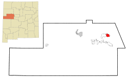 Lage in New Mexico
Basisdaten Staat: Vereinigte Staaten Bundesstaat: New Mexico County: Koordinaten: 35° 8′ N, 107° 22′ W35.137222222222-107.370833333331874Koordinaten: 35° 8′ N, 107° 22′ W Zeitzone: Mountain Standard Time (UTC−7) Einwohner: 474 (Stand: 2000) Bevölkerungsdichte: 24,7 Einwohner je km² Fläche: 19,2 km² (ca. 7 mi²)
davon 19,2 km² (ca. 7 mi²) LandHöhe: 1874 m Postleitzahl: 87040 Vorwahl: +1 505 FIPS: 35-54710 GNIS-ID: 0928765 Paguate ist ein Dorf im Nordwesten des US-Bundesstaates New Mexico im Cibola County. Es hat 474 Einwohner und eine Fläche von 19,2 km². Die Bevölkerungsdichte liegt bei 24,7 Einwohner je km². Die Koordinaten sind 35°8'14 "Nord, 107°22'15" West. Paguate liegt im Laguna-Indianerreservat.
 Orte im Cibola County
Acomita Lake | Encinal | Grants | Laguna | Mesita | Milan | North Acomita Village | Paguate | Paraje | Pinehill | Seama | Skyline-Ganipa |
Wikimedia Foundation.
Schlagen Sie auch in anderen Wörterbüchern nach:
Paguate — Paguate, NM U.S. Census Designated Place in New Mexico Population (2000): 474 Housing Units (2000): 183 Land area (2000): 7.407890 sq. miles (19.186345 sq. km) Water area (2000): 0.015934 sq. miles (0.041268 sq. km) Total area (2000): 7.423824 sq … StarDict's U.S. Gazetteer Places
Paguate, NM — U.S. Census Designated Place in New Mexico Population (2000): 474 Housing Units (2000): 183 Land area (2000): 7.407890 sq. miles (19.186345 sq. km) Water area (2000): 0.015934 sq. miles (0.041268 sq. km) Total area (2000): 7.423824 sq. miles… … StarDict's U.S. Gazetteer Places
Paguate, New Mexico — Infobox Settlement official name = Paguate, New Mexico settlement type = CDP nickname = motto = imagesize = image caption = image imagesize = image caption = image mapsize = 250px map caption = Location of Paguate, New Mexico mapsize1 = map… … Wikipedia
87040 — Paguate, Nm (Miscellaneous » ZIP Codes) … Abbreviations dictionary
Cibola County, New Mexico — Cibola County Courthouse in Grants, New Mexico … Wikipedia
Laguna Pueblo — or Pueblo of Laguna (Western Keres: Kawaik) is a Native American tribe of the Pueblo people in west central New Mexico, USA. The name, Laguna, is Spanish (meaning lagoon ) and derives from the lake located on their reservation. The real Keresan… … Wikipedia
Cibola County (New Mexico) — Verwaltung US Bundesstaat: New Mexico Verwaltungssitz: Grants Adresse des Verwaltungssitzes: County Courthouse 515 W High Street Grants, NM 87020 2526 Gründung … Deutsch Wikipedia
Anaconda Copper — Le Berkeley Pit, mine à ciel ouvert, où l extraction de cuivre commença en 1955 sous l égide d Anaconda. Anaconda Copper était, au début du XXe siècle, le premier producteur mondial de cuivre, exploitant les gisements de la ville de Butte,… … Wikipédia en Français
Mesita, New Mexico — Mesita redirects here. For the unincorporated town in Colorado, see Mesita, Colorado. Mesita, New Mexico CDP … Wikipedia
Milan, New Mexico — Village Location of Mil … Wikipedia
Paguate

18+
© Academic, 2000-2024
- Kontaktieren Sie uns: Unterstützung, Werbung
Wörterbücher Export, schritte mit PHP, Joomla, Drupal, WordPress, MODx.