Cibola County (New Mexico)

Cibola County (New Mexico)
Verwaltung
US-Bundesstaat: New Mexico
Verwaltungssitz: Grants
Adresse des
Verwaltungssitzes:
County Courthouse
515 W High Street
Grants, NM 87020-2526
Gründung: 19. Juni 1981
Gebildet aus: Valencia County
Vorwahl: 001 505
Demographie
Einwohner: 25.595  (2000)
Bevölkerungsdichte: 2,2 Einwohner/km²
Geographie
Fläche gesamt: 11.756 km²
Wasserfläche: 6 km²
Karte
Karte von Cibola County innerhalb von New Mexico

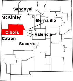
Cibola County ist ein County im Nordwesten des US-Bundesstaates New Mexico. Es hat 25.595 Einwohner. Der Sitz der Countyverwaltung (County Seat) ist in Grants.

Inhaltsverzeichnis

Geographie

Das County hat eine Fläche von 11.763 km², davon sind 11.756 km² Land und 6 km² (0,06 %) Wasser.

Nachbar-Countys

Geschichte

Cibola County wurde am 19. Juni 1981 aus Teilen des Valencia County gebildet und ist das jüngste County in New Mexico.

Städte und Dörfer


34.919998-107.9899967Koordinaten: 34° 55′ N, 107° 59′ W


Wikimedia Foundation.

Игры ⚽ Поможем решить контрольную работу

Schlagen Sie auch in anderen Wörterbüchern nach:

  • Cibola County, New Mexico — Cibola County Courthouse in Grants, New Mexico …   Wikipedia

  • San Mateo Mountains (Cibola County, New Mexico) — For other mountain ranges with this name, see San Mateo Mountains. The San Mateo Mountains are a small mountain range in Cibola and McKinley counties of New Mexico, in the southwestern United States. The highest point in the range is Mount Taylor …   Wikipedia

  • Bernalillo County (New Mexico) — Verwaltung US Bundesstaat: New Mexico Verwaltungssitz: Albuquerque Adresse des Verwaltungssitzes: Gründung …   Deutsch Wikipedia

  • Catron County (New Mexico) — Verwaltung US Bundesstaat: New Mexico Verwaltungssitz: Reserve Adresse des Verwaltungssitzes: Gründung: 25. Februar 1921 …   Deutsch Wikipedia

  • McKinley County, New Mexico — McKinley County Courthouse in Gallup, New Mexico …   Wikipedia

  • Catron County, New Mexico — Infobox U.S. County county = Catron County state = New Mexico | map size = 225 founded = 25 February 1921 seat = Reserve | largest city = Reserve area total sq mi =6929 area land sq mi =6928 area water sq mi =1 area percentage = 0.02% census yr …   Wikipedia

  • Bernalillo County, New Mexico — Infobox U.S. County county = Bernalillo County state = New Mexico map size = 200 founded = 1852 seat = Albuquerque | area total sq mi =1169 area land sq mi =1166 area water sq mi =3 area percentage = 0.22% census yr = 2000 pop = 556678 density… …   Wikipedia

  • Sandoval County, New Mexico — Infobox U.S. County county = Sandoval County state = New Mexico map size = 200 founded =1903 seat = Bernalillo | largest city = Rio Rancho area total sq mi =3714 area water sq mi =5 area percentage = 0.13% census yr = 2000 pop = 89908 density km2 …   Wikipedia

  • Socorro County, New Mexico — Infobox U.S. County county = Socorro County state = New Mexico map size = 200 founded = 1 July 1850 seat = Socorro | largest city = Socorro area total sq mi =6649 area water sq mi =2 area percentage = 0.03% census yr = 2000 pop = 18078 density… …   Wikipedia

  • Valencia County, New Mexico — Infobox U.S. County county = Valencia County state = New Mexico map size = 200 founded = 9 January 1852 seat = Los Lunas | largest city = Los Lunas area total sq mi =1068 area water sq mi =1 area percentage = 0.05% census yr = 2000 pop = 66152… …   Wikipedia

Share the article and excerpts

Direct link
Do a right-click on the link above
and select “Copy Link”