- Plymouth County (Massachusetts)
-
Verwaltung US-Bundesstaat: Massachusetts Verwaltungssitz: Brockton
PlymouthGründung: 1685 Demographie Einwohner: 492.409 (2005) Bevölkerungsdichte: 287,6 Einwohner/km² Geographie Fläche gesamt: 2.832 km² Wasserfläche: 1.120 km² Karte 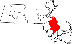
Das Plymouth County[1] ist ein County im Bundesstaat Massachusetts der Vereinigten Staaten von Amerika. Der Verwaltungssitz (County Seat) ist Brockton und Plymouth.
Inhaltsverzeichnis
Geographie
Das County hat eine Fläche von 2832 Quadratkilometern, wovon 1120 Quadratkilometer Wasserfläche sind. Es grenzt im Uhrzeigersinn an folgende Countys: Norfolk County, Barnstable County und Bristol County.
Geschichte
Plymouth County war 1685 eines von drei Gründungscountys von Plymouth Colony.
Bevölkerungsentwicklung
1980 1990 2000 2005 404.977 435.276 472.822 492.409 Demographie
Laut der Volkszählung im Jahr 2000 lebten im Plymouth County 472.822 Einwohner in 168.361 Haushalten und 122.398 Familien. Die Bevölkerung setzte sich aus 88,70 Prozent Weißen, 4,56 Prozent Afroamerikanern, 0,92 Prozent Asiaten und 0,21 Prozent amerikanischen Ureinwohnern zusammen. 2,44 Prozent der Bevölkerung waren spanischer oder lateinamerikanischer Abstammung. Das Pro-Kopf-Einkommen betrug 24.789 US-Dollar; 4,9 Prozent der Familien sowie 6,6 Prozent der Bevölkerung lebten unter der Armutsgrenze. [2]
Städte und Gemeinden
- Abington
- Bridgewater
- Brockton
- Carver
- Duxbury
- East Bridgewater
- Halifax
- Hanover
- Hanson
- Hingham
- Hull
- Kingston
- Lakeville
- Marion
- Marshfield
- Mattapoisett
- Middleborough
- Norwell
- Pembroke
- Plymouth
- Plympton
- Rochester
- Rockland
- Scituate
- Wareham
- West Bridgewater
- Whitman
Einzelnachweise
- ↑ GNIS-ID: 606938. Abgerufen am 22. Februar 2011 (englisch).
- ↑ Plymouth County, Massachusetts, Datenblatt mit den Ergebnissen der Volkszählung im Jahre 2000 bei factfinder.census.gov.
Weblinks
 Commons: Plymouth County (Massachusetts) – Sammlung von Bildern, Videos und Audiodateien
Schlagen Sie auch in anderen Wörterbüchern nach:
Plymouth County, Massachusetts — Infobox U.S. County county = Plymouth County state = Massachusetts seallink = show map size = 200 founded = 1685 seat = Plymouth and Brockton | area total sq mi = 1093 area total km2 = 2832 area land sq mi = 661 area land km2 = 1712 area water sq … Wikipedia
National Register of Historic Places listings in Plymouth County, Massachusetts — Location of Plymouth County in Massachusetts This is a list of the National Register of Historic Places listings in Plymouth County, Massachusetts. This is intended to be a complete list of the properties and districts on the National Register of … Wikipedia
Historical U.S. Census Totals for Plymouth County, Massachusetts — This article shows U.S. Census totals for Plymouth County, Massachusetts, broken down by municipality, from 1900 to 2000.Like most areas of New England, Plymouth County is (and has been at all times since well before the 20th century) entirely… … Wikipedia
Cormorant Rock (Plymouth County, Massachusetts) — Cormorant Rock is an island in Plymouth County, Massachusetts, USA. Categories: Islands of MassachusettsLandforms of Plymouth County, MassachusettsMassachusetts geography stubs … Wikipedia
List of Registered Historic Places in Plymouth County, Massachusetts — List of Registered Historic Places in Plymouth County, Massachusetts: =Brockton= =Hanover= =Hull= =Marion= =Middleborough= =Plymouth= =Rockland= =West Bridgewater= =Whitman= References … Wikipedia
Plymouth Center, Massachusetts — Plymouth Center is a census designated place (CDP) in the town of Plymouth in Plymouth County, Massachusetts, United States. It is often referred to as Downtown Plymouth. The population was 7,658 at the 2000 census.Plymouth Center is considered… … Wikipedia
Seal of Plymouth County, Massachusetts — FORCETOC The seal was adopted by the Plymouth County Commissioners on March 31, 1931 under the authority of the General Laws, Chapter 34, Section 14, and was designed by Frederic T. Bailey of North Scituate who was, at that time and for many… … Wikipedia
Plymouth County — is the name of two counties in the United States:* Plymouth County, Iowa * Plymouth County, Massachusetts … Wikipedia
Plymouth County — Es gibt in den Vereinigten Staaten zwei Countys mit dem Namen Plymouth County: Plymouth County (Iowa) Plymouth County (Massachusetts) Diese Seite ist eine Begriffsklärung zur Unterscheidung mehrerer mit demsel … Deutsch Wikipedia
Bar Rock (Plymouth County, Massachusetts) — Bar Rock is a barren rock within Massachusetts Bay, in Scituate, Massachusetts, USA. The rock is just east of the Scituate neighborhood of Minot, off the coast of Scituate Neck. More specifically, the rock is east of the Bailey s Causeway Glades… … Wikipedia
Plymouth County (Massachusetts)

18+
© Academic, 2000-2025
- Kontaktieren Sie uns: Unterstützung, Werbung
Wörterbücher Export, schritte mit PHP, Joomla, Drupal, WordPress, MODx.