- Franklin County (Massachusetts)
-
Verwaltung US-Bundesstaat: Massachusetts Verwaltungssitz: Greenfield Gründung: 1811 Demographie Einwohner: 72.334 (2005) Bevölkerungsdichte: 39,8 Einwohner/km² Geographie Fläche gesamt: 1.877 km² Wasserfläche: 59 km² Karte 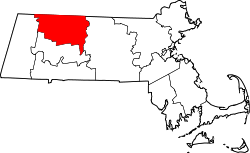
Das Franklin County[1] ist ein County im Bundesstaat Massachusetts der Vereinigten Staaten von Amerika. Der Verwaltungssitz (County Seat) ist Greenfield. Nach Abschaffung der Bezirksregierung 1997 existiert das County nur noch als historische geographische Region und dient einigen administrativen Zwecken.
Inhaltsverzeichnis
Regierung
Wie eine knappe Mehrheit der Countys in Massachusetts besitzt das Franklin County heute keine County-Regierung mehr. Alle vorherigen Aufgaben des Countys wurden 1997 durch Staatsbehörden übernommen. Der Sheriff und einige andere regionale Beamte mit besonderen Aufgaben werden noch immer lokal gewählt, um Aufgaben innerhalb des Countys wahrzunehmen. Die Gemeinden haben nun eine größere Autonomie und können regionale Verträge abschließen, um Dienstleistungen gemeinsam anzubieten.
Siehe auch: League of Women Voters Seite über die Countys
Geographie
Das County hat eine Fläche von 1877 Quadratkilometern, wovon 59 Quadratkilometer Wasserfläche sind. Es grenzt im Uhrzeigersinn an folgende Countys: Windham County (Vermont), Cheshire County (New Hampshire), Worcester County, Hampshire County und Berkshire County.
Geschichte
Das Franklin County wurde 1811 aus Teilen des Hampshire County gebildet.
Bevölkerungsentwicklung
1980 1990 2000 2005 64.333 70.092 71.535 72.334 Demographie
Laut der Volkszählung im Jahr 2000 lebten im Franklin County 71.535 Einwohner in 29.466 Haushalten und 18.416 Familien. Die Bevölkerung setzte sich aus 95,40 Prozent Weißen, 0,89 Prozent Afroamerikanern, 1,04 Prozent Asiaten und 0,29 Prozent amerikanischen Ureinwohnern zusammen. 1,99 Prozent der Bevölkerung waren spanischer oder lateinamerikanischer Abstammung. Das Pro-Kopf-Einkommen betrug 20.672 US-Dollar; 6,5 Prozent der Familien sowie 9,4 Prozent der Bevölkerung lebten unter der Armutsgrenze. [2]
Städte und Gemeinden

Whately - Ashfield
- Bernardston
- Buckland
- Charlemont
- Colrain
- Conway
- Deerfield
- Erving
- Gill
- Greenfield
- Hawley
- Heath
- Leverett
- Leyden
- Monroe
- Montague
- New Salem
- Northfield
- Orange
- Rowe
- Shelburne
- Shutesbury
- Sunderland
- Warwick
- Wendell
- Whately
Einzelnachweise
- ↑ GNIS-ID: 606932. Abgerufen am 22. Februar 2011 (englisch).
- ↑ Franklin County, Massachusetts, Datenblatt mit den Ergebnissen der Volkszählung im Jahre 2000 bei factfinder.census.gov.
Weblinks
 Commons: Franklin County – Sammlung von Bildern, Videos und Audiodateien
Schlagen Sie auch in anderen Wörterbüchern nach:
Franklin County, Massachusetts — Infobox U.S. County county = Franklin County state = Massachusetts map size = 200 founded = 1811 seat = None (formerly Greenfield) County government was abolished in 1997 | area total sq mi = 725 area total km2 = 1877 area total sq mi = 702 area… … Wikipedia
National Register of Historic Places listings in Franklin County, Massachusetts — Location of Franklin County in Massachusetts This is a list of the National Register of Historic Places listings in Franklin County, Massachusetts. This is intended to be a complete list of the properties and districts on the National Register of … Wikipedia
Historical U.S. Census Totals for Franklin County, Massachusetts — This article shows U.S. Census totals for Franklin County, Massachusetts, broken down by municipality, from 1900 to 2000.Like most areas of New England, Franklin County is (and has been at all times since well before the 20th century) entirely… … Wikipedia
Sugarloaf Mountain (Franklin County, Massachusetts) — This article is about Sugarloaf Mountain in Franklin County, Massachusetts. For other summits by the same name, see Sugarloaf (mountain). Sugarloaf Mountain (South Sugarloaf and North Sugarloaf) South and North Sugarloaf viewed from Mt. Toby … Wikipedia
List of Registered Historic Places in Franklin County, Massachusetts — List of Registered Historic Places in Franklin County, Massachusetts: :: Massachusetts NRHP date for lists ee also*List of National Historic Landmarks in MassachusettsReferences … Wikipedia
Franklin County — may refer to places: in Australia Franklin County, New South Wales the former name of Franklin Land District, Tasmania in New Zealand Franklin County, New Zealand in the United States It is the name of 24 counties and a parish in the United… … Wikipedia
Franklin County Sheriff's Office — could refer to several sheriffs departments in the United States, including:* Franklin County, Alabama Sheriff s Office * Franklin County, Arkansas Sheriff s Office * Franklin County, Florida Sheriff s Office * Franklin County, Georgia Sheriff s… … Wikipedia
Franklin County — Es gibt in den Vereinigten Staaten 25 Countys oder Parishes mit dem Namen Franklin: Franklin County (Alabama) Franklin County (Arkansas) Franklin County (Florida) Franklin County (Georgia) Franklin County (Idaho) Franklin County (Illinois)… … Deutsch Wikipedia
Middlesex County, Massachusetts — Verwaltung US Bundesstaat: Massachusetts Verwaltungssitz: Cambridge Lowell Adresse des Verwaltungssitzes … Deutsch Wikipedia
Worcester County, Massachusetts — Infobox U.S. County county = Worcester County state = Massachusetts map size = 225 founded = April 2, 1731 seat = None (formerly Worcester) County government was abolished in 1998 | area total sq mi = 1579 area total km2 = 4090 area land sq mi =… … Wikipedia
Franklin County (Massachusetts)


18+
© Academic, 2000-2026
- Kontaktieren Sie uns: Unterstützung, Werbung
Wörterbücher Export, schritte mit PHP, Joomla, Drupal, WordPress, MODx.