- Queanbeyan
-
Queanbeyan 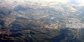
Luftaufnahme von QueanbeyanStaat:  Australien
Bundesstaat:  New South Wales
Gegründet: 1838 Koordinaten: 35° 21′ S, 149° 14′ O-35.354166666667149.23138888889576Koordinaten: 35° 21′ S, 149° 14′ O Höhe: 576 m Fläche: 172,88 km² Einwohner: 34.084 (2006 [1]) Bevölkerungsdichte: 197 Einwohner je km² Zeitzone: AEST (UTC+10) LGA: Queanbeyan City Council 

Queanbeyan Queanbeyan ist eine Stadt und Hauptort der Local Government Area Queanbeyan City im Südosten des australischen Bundesstaates New South Wales. Die Stadt grenzt unmittelbar an die australische Hauptstadt Canberra und das Australian Capital Territory. Die Distanz zwischen den beiden Stadtzentren beträgt rund 10 Kilometer. Die Grenze verläuft entlang der Bahnlinie. Durch die Stadt fließt der Queanbeyan River. Im Jahr 2006 zählte Queanbeyan 34.084 Einwohner, die Fläche des Stadtgebiets beträgt 172,88 km².
Persönlichkeiten
- David Campese (* 1962), Rugby-Union-Spieler
- George Lazenby (* 1939), Dressman und Schauspieler
- Heather McKay (* 1941), Squashspielerin
- Mark Webber (* 1976), Formel-1-Rennfahrer
Weblinks
Einzelnachweise
- ↑ Australian Bureau of Statistics (25. Oktober 2007): Canberra-Queanbeyan (Queanbeyan Part) (Urban Centre/Locality) (Englisch). 2006 Census QuickStats. Abgerufen am 17. April 2009.
Kategorie:- Ort in New South Wales


Wikimedia Foundation.