Rabaul (Caldera)

Rabaul (Caldera)
Tavurvur
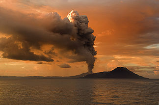
Höhe 223 m
Lage Papua-Neuguinea
Geographische Lage 4° 16′ 15″ S, 152° 12′ 10″ O-4.2708333333333152.20277777778223Koordinaten: 4° 16′ 15″ S, 152° 12′ 10″ O
Tavurvur (Papua-Neuguinea)
DEC
Tavurvur
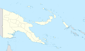
Typ Vulkan
Letzte Eruption 7. Oktober 2006

Tavurvur ist ein Vulkan in Papua-Neuguinea nahe der Stadt Rabaul.

Zuletzt brach er am 7. Oktober 2006 aus und eine Aschenwolke wurde bis 18 Kilometer in die Stratosphäre geschleudert. Zuvor brach der Vulkan 1994 aus. Damals wurde Rabaul unter Asche begraben und musste an anderer Stelle neu aufgebaut werden. Zahlreiche Verwaltungszentren wurden nach Kokopo verlegt.

Der Vulkan liegt innerhalb der 8 mal 14 km großen Rabaul-Caldera, die um etwa 550 n. Chr. bei einem massiven Vulkanausbruch der Stärke 6 auf dem Vulkanexplosivitätsindex entstanden ist. Gelegentlich wird diskutiert, ob dieser Ausbruch für die Klimaveränderungen von 535-536 verantwortlich sein könnte, doch ist dies umstritten.

Weblinks


Wikimedia Foundation.

Игры ⚽ Нужно решить контрольную?

Schlagen Sie auch in anderen Wörterbüchern nach:

  • Rabaul caldera — Tavurvur spewing ash in February 2009. To the right is Turangan, and Kombiu is partly visible behind Turangan. Elevation …   Wikipedia

  • Rabaul Airport — Rabaul Airport, also called Tokua Airport, is an airport servicing Kokopo and Rabaul in Papua New Guinea airport codes|RAB|AYRB.Prior to the 1994 volcanic eruption that destroyed the town of Rabaul, the airport was located at the foot of Tavurvur …   Wikipedia

  • Rabaul — For the volcanic caldera within which Rabaul lies, see Rabaul caldera. Rabaul East New Britain Papua New Guinea …   Wikipedia

  • Rabaul — Staat: Papua Neuguinea …   Deutsch Wikipedia

  • Caldéra — Caldeira Une caldeira (du portugais caldeira, qui signifie « chaudron ») est un terme de volcanologie. En français, les deux orthographes, « caldeira » ou « caldera » (sans accent), sont autorisées. Sommaire 1… …   Wikipédia en Français

  • Tavurvur — Infobox Mountain Name = Rabaul caldera Photo = Rabaul Harbor And Tavurur From Volcano Observatory.jpeg Caption = A view of Tavurur from Rabaul Volcano Observatory. Elevation = Convert|223|m|ft|0|abbr=on Location = East New Britain, Papua New… …   Wikipedia

  • Tavurvur — Höhe 223 m …   Deutsch Wikipedia

  • Tavurvur — en actividad volcánica. Tipo Estratovolcán (activo) Ubicación …   Wikipedia Español

  • New Britain — This article is about the island of New Britain in Papua New Guinea. For other uses of the name, see New Britain (disambiguation). New Britain New Britain from space, June 2005. Clearly visible are ash plumes from Langila and Ulawun volcanoes …   Wikipedia

  • eruption cloud — ALASKA VOLCANO OBSERVATORY GLOSSARY Cloud of gas, ash, and other fragments that forms during an explosive volcanic eruption and travels long distances with the prevailing winds. USGS PHOTO GLOSSARY OF VOLCANIC TERMS A cloud of tephra and gases… …   Glossary of volcanic terms

Share the article and excerpts

Direct link
Do a right-click on the link above
and select “Copy Link”