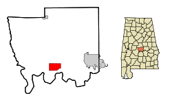
Autaugaville

Autaugaville
Icon tools.svg Dieser Artikel wurde aufgrund von inhaltlichen Mängeln auf der Qualitätssicherungsseite des Projektes USA eingetragen. Hilf mit, die Qualität dieses Artikels auf ein akzeptables Niveau zu bringen, und beteilige dich an der Diskussion!
US-GreatSeal-Obverse.svg
Autaugaville
Autauga County Alabama Incorporated and Unincorporated areas Autaugaville Highlighted.svg
Lage in Alabama
Basisdaten
Staat: Vereinigte Staaten
Bundesstaat: Alabama
County:

Autauga County

Koordinaten: 32° 26′ N, 86° 39′ W32.4325-86.65333333333349Koordinaten: 32° 26′ N, 86° 39′ W
Zeitzone: Eastern Standard Time (UTC−5)
Einwohner: 820 (Stand: 2000)
Bevölkerungsdichte: 41 Einwohner je km²
Fläche: 20,4 km² (ca. 8 mi²)
davon 20,0 km² (ca. 8 mi²) Land
Höhe: 49 m
Postleitzahl: 36003
Vorwahl: +1 334
FIPS: 01-03220
GNIS-ID: 0113299
Bürgermeister: F.B. Ward

Autaugaville ist ein Ort im Autauga County, Alabama, USA. Nach der Volkszählung aus dem Jahr 2000 hatte Autaugaville 820 Einwohner. Nach einer Schätzung im Jahr 2005 waren es 865 Einwohner. Der Ort hat eine Gesamtfläche von 20,5 km², wovon 20,0 km² Land sind.

Demographie

Nach der Volkszählung aus dem Jahr 2000 hatte Autaugaville 820 Einwohner die sich auf 316 Haushalte sowie 219 Familien verteilten. Die Bevölkerungsdichte betrug 41 Einwohner/km². 32,32% der Bevölkerung waren weiß, 65,98% afroamerikanisch. In 34,5% der Haushalte lebten Kinder unter 18 Jahren. Das Durchschnittseinkommen betrug 22563 Dollar. 27,1% der Bevölkerung lebten unter der Armutsgrenze.

Quelle


Wikimedia Foundation.

Игры ⚽ Поможем написать реферат

Schlagen Sie auch in anderen Wörterbüchern nach:

  • Autaugaville — Autaugaville, AL U.S. town in Alabama Population (2000): 820 Housing Units (2000): 384 Land area (2000): 7.730675 sq. miles (20.022355 sq. km) Water area (2000): 0.167500 sq. miles (0.433822 sq. km) Total area (2000): 7.898175 sq. miles… …   StarDict's U.S. Gazetteer Places

  • Autaugaville, AL — U.S. town in Alabama Population (2000): 820 Housing Units (2000): 384 Land area (2000): 7.730675 sq. miles (20.022355 sq. km) Water area (2000): 0.167500 sq. miles (0.433822 sq. km) Total area (2000): 7.898175 sq. miles (20.456177 sq. km) FIPS… …   StarDict's U.S. Gazetteer Places

  • Autaugaville — 32° 25′ 56″ N 86° 39′ 12″ W / 32.432222, 86.653333 …   Wikipédia en Français

  • Autaugaville (Alabama) — Autaugaville Autaugaville Pays  États Unis État Alabama Comté Autauga …   Wikipédia en Français

  • Autaugaville (Alabama) — Saltar a navegación, búsqueda Autaugaville, Alabama Bandera …   Wikipedia Español

  • Autaugaville School — Infobox School name = Autaugaville School district = Autaugaville, Alabama principal = John Clay staff = 35 students = 476 athletics = Yes country = USA website = [http://teacherweb.com/al/AutaugavilleSchool/ASHOMEPAGE/h0.stm Autaugaville School] …   Wikipedia

  • Autaugaville, Alabama — Infobox Settlement official name = Autaugaville, Alabama settlement type = Town imagesize = image caption = image imagesize = image caption = image mapsize = 250px map caption = Location in Autauga County and the state of Alabama mapsize1 = map… …   Wikipedia

  • 36003 — Autaugaville, Al (Miscellaneous » ZIP Codes) …   Abbreviations dictionary

  • Comté d'Autauga — (Autauga County) Localisation dans l Alabama …   Wikipédia en Français

  • Autauga County School System — Autauga County School System, based in Autauga County, Alabama, has 13 schools and over 9,900 students as of 2007.The schools are located in the communities of Billingsley, Pine Level, and Marbury, and the cities of Autaugaville and… …   Wikipedia

Share the article and excerpts

Direct link
Do a right-click on the link above
and select “Copy Link”