- Romorantin-Lanthenay (Arrondissement)
-
Arrondissement Romorantin-Lanthenay Staat Frankreich Region Centre Département Loir-et-Cher Unterpräfektur Romorantin-Lanthenay Einwohner
– insgesamt
– Bevölkerungsdichte
– Rang (im Dép.)(1999)
69.672
34 Einw./km²
2Fläche 2.059 km² Kantone 7 Gemeinden 48 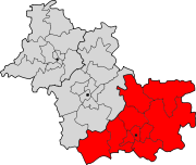
Lage des Arrondissement Romorantin-Lanthenay im Département Loir-et-CherDas Arrondissement Romorantin-Lanthenay ist eine Verwaltungseinheit des französischen Départements Loir-et-Cher innerhalb der Region Centre. Verwaltungssitz (Unterpräfektur) ist Romorantin-Lanthenay.
Es besteht aus sieben Kantonen und 48 Gemeinden.
Kantone
- Lamotte-Beuvron
- Mennetou-sur-Cher
- Neung-sur-Beuvron
- Romorantin-Lanthenay-Nord
- Romorantin-Lanthenay-Sud
- Salbris
- Selles-sur-Cher
Le Blanc | Blois | Bourges | Chartres | Châteaudun | Châteauroux | La Châtre | Chinon | Dreux | Issoudun | Loches | Montargis | Nogent-le-Rotrou | Orléans | Pithiviers | Romorantin-Lanthenay | Saint-Amand-Montrond | Tours | Vendôme | Vierzon

Wikimedia Foundation.