Rushcliffe — Infobox UK district name = Borough of Rushcliffe status = Borough region = East Midlands admincounty = Nottinghamshire area = Ranked 114th 409.24 km² adminhq = West Bridgford onscode = 37UJ population = Ranked English district rank|ONS=37UJ… … Wikipedia
Rushcliffe — 52° 54′ N 1° 03′ W / 52.90, 1.05 … Wikipédia en Français
Rushcliffe — ▪ district, England, United Kingdom borough (district), administrative and historic county of Nottinghamshire, central England, immediately southeast of the city of Nottingham. Rushcliffe is a rural agricultural area of open, rolling… … Universalium
Rushcliffe (wapentake) — Rushcliffe was a wapentake (equivalent to a hundred) of the historic county of Nottinghamshire, England. It was in the south of the county, on the south side of the River Trent, covering the parishes of Barton in Fabis, Bradmore, Bunny, Clifton… … Wikipedia
Rushcliffe Halt — is a railway station serving the north of East Leake, and is the only surviving Great Central Railway London Extension station with twin platforms (as opposed to the standard island platform). The stations was built as a later addition to the… … Wikipedia
Rushcliffe Country Park — Infobox park park= Rushcliffe Country Park image size= caption= type= Country Park location= Ruddington, UK coordinates= coord|52.8925|N|1.1497|W|type:landmark region:GB|display=title,inline size= 210 Acres opened= 1993 operator= Rushcliffe… … Wikipedia
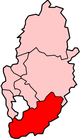
Rushcliffe (UK Parliament constituency) — UK constituency infobox Name = Rushcliffe Map1 = Rushcliffe Map2 = Nottinghamshire Type = County Year = 1885 Entity =Nottinghamshire County = Nottinghamshire EP = East Midlands MP = Kenneth Clarke Party = ConservativeRushcliffe is a county… … Wikipedia
Henry Betterton, 1st Baron Rushcliffe — Henry Bucknall Betterton, 1st Baron Rushcliffe, Bt, GBE, PC (15 August 1872 ndash; 18 November 1949) was a British Conservative Party politician.Betterton was a lawyer, practising for some years at the Chancery Bar.He was elected as Member of… … Wikipedia
Gamston, Rushcliffe — Gamston lies near West Bridgford, and is a suburb of Nottingham, only ten minutes away. It is part of the West Bridgford postcode of NG2. There is a village of the same name near Retford. The homes in Gamston are new builds built betwn 1980 and… … Wikipedia
West Bridgford — infobox UK place country = England latitude= 52.92 longitude= 1.13 map type = Nottinghamshire official name= West Bridgford population = shire district= Rushcliffe shire county = Nottinghamshire region= East Midlands constituency westminster=… … Wikipedia