- Saguiaran
-
Municipality of Saguiaran Lage von Saguiaran in der Provinz Lanao del Sur 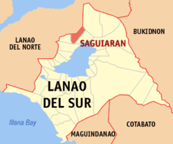
Basisdaten Bezirk: Autonomous Region in Muslim Mindanao Provinz: Lanao del Sur Barangays: 30 Distrikt: 1. Distrikt von Lanao del Sur PSGC: 153625000 Einkommensklasse: 4. Einkommensklasse Haushalte: 3074 Zensus 1. Mai 2000Einwohnerzahl: 23.274 Zensus 1. August 2007Koordinaten: 8° 2′ N, 124° 16′ O8.0333333333333124.26666666667Koordinaten: 8° 2′ N, 124° 16′ O Postleitzahl: 9701 Bürgermeister: Rasmia B. Macabago Offizielle Webpräsenz: www.saguiaran-lds.gov.ph Geographische Lage auf den Philippinen 

Saguiaran Saguiaran ist eine philippinische Stadtgemeinde in der Provinz Lanao del Sur. Nach dem Zensus vom 1. Mai 2000 hat sie 22.636 Einwohner in 3074 Haushalten.
Baranggays
Saguiaran ist politisch in 30 Baranggays unterteilt.
- Alinun
- Bagoaingud
- Batangan
- Cadayon
- Cadingilan
- Lumbac Toros
- Comonal
- Dilausan
- Gadongan
- Linao
- Limogao
- Lumbayanague
- Basak Maito
- Maliwanag
- Mapantao
- Mipaga
- Natangcopan
- Pagalamatan
- Pamacotan
- Panggao
- Pantao Raya
- Pantaon
- Patpangkat
- Pawak
- Dilimbayan
- Pindolonan
- Poblacion
- Salocad
- Sungcod
- Bubong
Städte und Stadtgemeinden in der Provinz Lanao del SurStädte: Marawi City
Stadtgemeinden: Bacolod-Kalawi | Balabagan | Balindong | Bayang | Binidayan | Buadiposo-Buntong | Bubong | Bumbaran | Butig | Calanogas | Ditsaan-Ramain | Ganassi | Kapai | Kapatagan | Lumba-Bayabao | Lumbaca-Unayan | Lumbatan | Lumbayanague | Madalum | Madamba | Maguing | Malabang | Marantao | Marogong | Masiu | Mulondo | Pagayawan | Piagapo | Picong | Poona Bayabao | Pualas | Saguiaran | Sultan Dumalondong | Tagoloan II | Tamparan | Taraka | Tubaran | Tugaya | Wao
Wikimedia Foundation.
Schlagen Sie auch in anderen Wörterbüchern nach:
Saguiaran — Original name in latin Saguiaran Name in other language Sagiaran, Saguiaran State code PH Continent/City Asia/Manila longitude 8.03306 latitude 124.27 altitude 630 Population 0 Date 2011 07 31 … Cities with a population over 1000 database
Saguiaran, Lanao del Sur — Saguiaran is a 4th class municipality in the province of Lanao del Sur, Philippines. According to the 2000 census, it has a population of 22,636 people in 3,074 households. It is a town just outside Marawi City. Saguiaran is located at the end of … Wikipedia
Marawi — For other uses, see Merowe. Islamic City of Marawi Lungsod Islamiko ng Marawwi Marawi City City … Wikipedia
Marawi City — Infobox Settlement official name = Islamic City of Marawi other name = native name = nickname = The Summer Capital of the South settlement type = motto = imagesize = image caption = Islamic Center of Marawi City flag size = image seal size =… … Wikipedia
Malabang, Lanao del Sur — Malabang is a 4th class municipality in the province of Lanao del Sur, Philippines. According to the 2000 census, it has a population of 33,177 people in 4,883 households. Contents 1 Municipality Mayor Anwar Balindong 2 History … Wikipedia
Marawi City — Lage von Marawi City in der Provinz Lanao del Sur Basisdaten Bezirk … Deutsch Wikipedia
PH-LAS — Lage von Lanao del Sur Lanao del Sur ist eine Provinz im Zentralteil der Insel Mindanao auf den Philippinen. Lanao del Sur gehört zum Bezirk ARMM, der Autonomous Region in Muslim Mindanao. Die Hauptstadt der Provinz liegt am Lake Lanao und heißt… … Deutsch Wikipedia
Marawi — Dakbayang Islamiko sa Marawi Ciudad Islámica de Marawi Marawi con una vista del Lanao Apodo(s): La Cabecera de Verano del Sur … Wikipedia Español
Provinces of the Philippines — The provinces of the Philippines are the primary administrative divisions of the Philippines. There are 81 provinces, further subdivided into cities and municipalities. The National Capital Region is autonomous of provincial government. Each… … Wikipedia
Lanao del Sur — Infobox Philippine province name = Lanao del Sur sealfile = Ph seal lanao del sur.png region = Autonomous Region in Muslim Mindanao (ARMM) capital = Marawi City founded = 1959 pop2000 = 800,162 pop2000rank = 29th largest popden2000 = 207… … Wikipedia
Saguiaran


18+
© Academic, 2000-2026
- Kontaktieren Sie uns: Unterstützung, Werbung
Wörterbücher Export, schritte mit PHP, Joomla, Drupal, WordPress, MODx.