- Ditsaan-Ramain
-
Municipality of Ditsaan-Ramain Lage von Ditsaan-Ramain in der Provinz Lanao del Sur 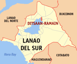
Basisdaten Bezirk: Autonomous Region in Muslim Mindanao Provinz: Lanao del Sur Barangays: 34 Distrikt: 1. Distrikt von Lanao del Sur PSGC: 153624000 Einkommensklasse: 4. Einkommensklasse Haushalte: 2682 Zensus 1. Mai 2000Einwohnerzahl: 25.425 Zensus 1. August 2007Koordinaten: 7° 58′ N, 124° 21′ O7.9666666666667124.35Koordinaten: 7° 58′ N, 124° 21′ O Postleitzahl: 9713 Bürgermeister: Actar M. Marmar Offizielle Webpräsenz: www.ditsaanramain-lds.gov.ph Geographische Lage auf den Philippinen 

Ditsaan-Ramain Ditsaan-Ramain ist eine philippinische Stadtgemeinde in der Provinz Lanao del Sur. Nach dem Zensus vom 1. Mai 2000 hat sie 19.157 Einwohner in 2682 Haushalten.
Baranggays
Ditsaan-Ramain ist politisch in 34 Baranggays unterteilt.
- Bagoaingud
- Barimbingan
- Bayabao
- Buadi Babai
- Buadi Alao
- Buadi Oloc
- Pagalongan Buadiadinga
- Dado
- Dangimprampiai
- Darimbang
- Dilausan
- Ditsaan
- Gadongan
- Pagalongan Ginaopan
- Baclayan Lilod
- Linamon
- Lumbatan Ramain
- Buayaan Madanding
- Maindig Ditsaan
- Mandara
- Maranao Timber (Dalama)
- Pagalongan Proper
- Polo
- Ramain Poblacion
- Ramain Proper
- Baclayan Raya
- Buayaan Raya
- Rantian
- Sundiga Bayabao
- Talub
- Buayaan Lilod
- Bubong Dangiprampiai
- Pagalongan Masioon
- Sultan Pangadapun
Städte und Stadtgemeinden in der Provinz Lanao del SurStädte: Marawi City
Stadtgemeinden: Bacolod-Kalawi | Balabagan | Balindong | Bayang | Binidayan | Buadiposo-Buntong | Bubong | Bumbaran | Butig | Calanogas | Ditsaan-Ramain | Ganassi | Kapai | Kapatagan | Lumba-Bayabao | Lumbaca-Unayan | Lumbatan | Lumbayanague | Madalum | Madamba | Maguing | Malabang | Marantao | Marogong | Masiu | Mulondo | Pagayawan | Piagapo | Picong | Poona Bayabao | Pualas | Saguiaran | Sultan Dumalondong | Tagoloan II | Tamparan | Taraka | Tubaran | Tugaya | Wao
Wikimedia Foundation.
Schlagen Sie auch in anderen Wörterbüchern nach:
Ditsaan-Ramain, Lanao del Sur — Ditsaan Ramain is a 4th class municipality in the province of Lanao del Sur, Philippines. According to the 2000 census, it has a population of 19,157 people in 2,682 households. Barangays Ditsaan Ramain is politically subdivided into 35 barangays … Wikipedia
Ramain — Original name in latin Ramain Name in other language Ditsaan Ramain, Ramain State code PH Continent/City Asia/Manila longitude 7.97083 latitude 124.34528 altitude 705 Population 0 Date 2011 07 31 … Cities with a population over 1000 database
Farouk Sharif — His Royal Highness Sultan FAROUK RAWA GANDAROSA SHARIF is the crowned Sultan of Taporog, Poona Bayabao, Lanao del Sur, PhilippinesReign: July 1998 presentBorn:Royal House: House of SharifFather: Late Abdullah SharifMother: Late Hadji Aminah Rawa… … Wikipedia
Confederation of sultanates in Lanao — The Sultanates of Lanao in Mindanao, Philippines were founded in the 16th century through the influence of Shariff Kabungsuan, who was enthroned as first Sultan of Maguindanao in 1520. The Maranaos of Lanao were acquainted with the sultanate… … Wikipedia
Marawi City — Infobox Settlement official name = Islamic City of Marawi other name = native name = nickname = The Summer Capital of the South settlement type = motto = imagesize = image caption = Islamic Center of Marawi City flag size = image seal size =… … Wikipedia
Malabang, Lanao del Sur — Malabang is a 4th class municipality in the province of Lanao del Sur, Philippines. According to the 2000 census, it has a population of 33,177 people in 4,883 households. Contents 1 Municipality Mayor Anwar Balindong 2 History … Wikipedia
Marawi City — Lage von Marawi City in der Provinz Lanao del Sur Basisdaten Bezirk … Deutsch Wikipedia
PH-LAS — Lage von Lanao del Sur Lanao del Sur ist eine Provinz im Zentralteil der Insel Mindanao auf den Philippinen. Lanao del Sur gehört zum Bezirk ARMM, der Autonomous Region in Muslim Mindanao. Die Hauptstadt der Provinz liegt am Lake Lanao und heißt… … Deutsch Wikipedia
Marawi — For other uses, see Merowe. Islamic City of Marawi Lungsod Islamiko ng Marawwi Marawi City City … Wikipedia
Bubong — Municipality of Bubong Lage von Bubong in der Provinz Lanao del Sur Basisdaten Bezirk … Deutsch Wikipedia
Ditsaan-Ramain


18+
© Academic, 2000-2026
- Kontaktieren Sie uns: Unterstützung, Werbung
Wörterbücher Export, schritte mit PHP, Joomla, Drupal, WordPress, MODx.