Saparevo

Saparevo
Saparewa Banja (Сапарева баня)
Wappen fehlt
Hilfe zu Wappen
Karte von Bulgarien, Position von Saparewa Banja hervorgehoben
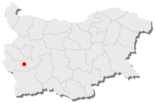
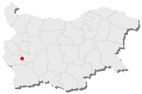
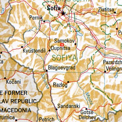
Basisdaten
Staat: Bulgarien
Oblast: Kjustendil
Einwohner: 4425 (13. Sept. 2005)
Koordinaten: 42° 17′ N, 23° 16′ O42.28333333333323.266666666667983Koordinaten: 42° 17′ 0″ N, 23° 16′ 0″ O
Höhe: 983 m
Postleitzahl: 2650
Telefonvorwahl: (+359) 0707
Kfz-Kennzeichen: KH
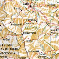
Saparewa Banja (rotes Viereck) - Bulgarien - Nachbarorte: Samokow, Dupniza, Kjustendil, Pernik, Sofia, Slatiza, Blagoewgrad, Raslog

Saparewa Banja [sɐpɐˈrɛvɐ ˈbanjɐ] (bulgarisch Сапарева баня) ist eine Stadt im Südwesten von Bulgarien. Sie liegt 45 km südlich von Sofia im Oblast Kjustendil. An einem Nordhang des Rila-Gebirges gelegen ist es Ausgangspunkt für Wanderungen und Ausflüge. Bekannt ist Saparewa Banja für den einzigen aktiven Geysir in Südosteuropa und sein 103°C heißes, schwefelhaltiges Heilwasser mit hohen Anteilen an Eisen, Mangan und Kalzium .

Weblinks


Wikimedia Foundation.

Игры ⚽ Нужно сделать НИР?

Schlagen Sie auch in anderen Wörterbüchern nach:

  • Saparevo Glacier — ( bg. ледник Сапарево , ‘Lednik Saparevo’ led nik sa pa re vo) is an 1.8 km long and 2 km wide glacier on Smith Island, South Shetland Islands draining the northwest slopes of Imeon Range. Flowing north of Mount Christi into Vedena Cove.… …   Wikipedia

  • Sapareva Banya — Infobox Settlement official name = PAGENAME native name = Сапарева баня subdivision type = Country subdivision name = BUL subdivision type1 = Provinces (Oblast) timezone=EET utc offset=+2 timezone DST=EEST utc offset DST=+3 map caption = Location …   Wikipedia

  • Radka Popova — Radka Popowa (bulgarisch Радка Попова; * 26. Januar 1974 in Dupniza) ist eine frühere bulgarische Biathletin. Radka Popowa, Lehrerin aus Saparevo, betreibt Biathlon seit 1992 und gehört seitdem auch dem bulgarischen Nationalteam an. Sie wird von… …   Deutsch Wikipedia

  • List of Bulgarian toponyms in Antarctica — Bulgarian toponyms in Antarctica are approved by the Antarctic Place names Commission in compliance with its Toponymic Guidelines , and formally given by the President of the Republic according to the Bulgarian Constitution and the established… …   Wikipedia

  • Mount Christi — Location of Smith Island in the South Shetland Islands. Mount Christi is a peak rising to 1280 m in the northern Imeon Range on Smith Island in the South Shetland Islands, Antarctica. The peak surmounts Saparevo Glacier to the north and Kongur… …   Wikipedia

  • Matochina Peak — Location of Smith Island in the South Shetland Islands. Matochina Point (Bulgarian: връх Маточина, ‘Vrah Matochina’ vr h ma to chi na) is a peak rising to 750 m in the north extremity of Imeon Range on Smith Island in the South Shetland Islands,… …   Wikipedia

  • Radka Popowa — (bulgarisch Радка Попова; * 26. Januar 1974 in Dupniza) ist eine frühere bulgarische Biathletin. Radka Popowa, Lehrerin aus Saparevo, betreibt Biathlon seit 1992 und gehört seitdem auch dem bulgarischen Nationalteam an. Sie wird von Kiril… …   Deutsch Wikipedia

  • Kyoustendil (oblast) — 42°15′N 23°0′E / 42.25, 23 …   Wikipédia en Français

  • Kyustendil (oblast) — Kyoustendil (oblast) Област Кюстендил (Oblast Kyustendil) Oblast de Kyoustendil Administration Pays Bulgarie Type Oblast Siège Kyoustendil …   Wikipédia en Français

  • Oblast de Kyoustendil — Kyoustendil (oblast) Област Кюстендил (Oblast Kyustendil) Oblast de Kyoustendil Administration Pays Bulgarie Type Oblast Siège Kyoustendil …   Wikipédia en Français

Share the article and excerpts

Direct link
Do a right-click on the link above
and select “Copy Link”