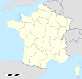
Tabanac

Tabanac
Tabanac
Tabanac (Frankreich)
Tabanac
Region Aquitanien
Département Gironde
Arrondissement Bordeaux
Kanton Créon
Koordinaten 44° 43′ N, 0° 24′ W44.720555555556-0.4055555555555776Koordinaten: 44° 43′ N, 0° 24′ W
Höhe 76 m (3–94 m)
Fläche 8,00 km²
Einwohner 1.058 (1. Jan. 2008)
Bevölkerungsdichte 132 Einw./km²
Postleitzahl 33550
INSEE-Code

Tabanac ist eine französische Gemeinde im Département Gironde in der Region Aquitanien. Die Gemeinde liegt im Einzugsgebiet der Stadt Bordeaux. Während Tabanac im Jahr 1962 noch über 536 Einwohner verfügte, zählt man aktuell 1058 Einwohner (Stand 1. Januar 2008).

Die Gemeinde gehört zum Kanton Créon im Arrondissement Bordeaux.

Tabanac ist eine Weinbaugemeinde; die Rebflächen gehören zu den Appellationen Premières Côtes de Bordeaux und Cadillac.


Wikimedia Foundation.

Игры ⚽ Нужно решить контрольную?

Schlagen Sie auch in anderen Wörterbüchern nach:

  • Tabanac — is a commune in the Gironde department in Aquitaine in southwestern France.It is located approximately a 30 minute drive from the centre of Bordeaux. The total land area is 7.95 km² stretching northwards from the Garonne river. In 2004 the… …   Wikipedia

  • Tabanac — País …   Wikipedia Español

  • Tabanac — 44° 43′ 17″ N 0° 24′ 16″ W / 44.7214, 0.404444444444 …   Wikipédia en Français

  • Tabanac — Original name in latin Tabanac Name in other language Coteau Libre, Tabanac State code FR Continent/City Europe/Paris longitude 44.72059 latitude 0.40513 altitude 77 Population 1072 Date 2012 01 18 …   Cities with a population over 1000 database

  • Château Sentout — is a castle in Tabanac, in the department of Gironde in southwestern France. It has been listed as a Monument historique since 1989[1]. History It is now converted to gîtes but its history can be traced back to at least 1650 (as documented in… …   Wikipedia

  • Castres-Gironde — Pour les articles homonymes, voir Castres (homonymie). 44° 41′ 50″ N 0° 26′ 37″ W …   Wikipédia en Français

  • Portets —  Ne doit pas être confondu avec Portet ni Portet sur Garonne. 44° 41′ 52″ N 0° 25′ …   Wikipédia en Français

  • Côtes-de-bordeaux — Bordeaux Désignation(s) Bordeaux Appellation(s) principale(s) côtes de bordeaux[1] Type d appellation(s) AOC Reconnue depuis 2009 Pays …   Wikipédia en Français

  • Communes of the Gironde department — The following is a list of the 542 communes of the Gironde département, in France. (CUB) Agglomeration community of Bordeaux, created in 1966. (CAA) Agglomeration community of the Bay of South Arcachon, created in 2002. INSEE code Postal code Co …   Wikipedia

  • Margaux — Margaux …   Wikipedia

Share the article and excerpts

Direct link
Do a right-click on the link above
and select “Copy Link”