Taveuni

Taveuni
Taveuni
Wasserfall auf Taveuni
Gewässer Pazifischer Ozean
Inselgruppe Fidschi-Inseln
Geographische Lage 16° 50′ S, 179° 57′ W-16.833055555556-179.949722222221241Koordinaten: 16° 50′ S, 179° 57′ W
Taveuni (Fidschi)
Taveuni
Länge 42 km
Breite 15 km
Fläche 442 km²
Höchste Erhebung Uluiqalau
1.241 m
Einwohner 12.000
27 Einw./km²
Hauptort Matei
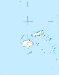
Reliefkarte von Taveuni

Taveuni ist mit 442 Quadratkilometern die drittgrößte Insel der Fidschi-Inseln.

Inhaltsverzeichnis

Geographie

Die Insel ist 42 km lang und 15 km breit und liegt genau auf dem 180. Längengrad. Nur 15 km entfernt, jenseits der Somosomo-Straße, liegt die zweitgrößte Insel Fidschis, Vanua Levu. Taveuni ist auch unter dem Namen die Garteninsel bekannt, da 60 % mit tropischem Regenwald bedeckt ist. Das Rückgrat der Insel bildet ein 16 km langer vulkanischer Rücken, einem Schildvulkan, der um 1550 das letzte Mal ausgebrochen war. Am höchsten Punkt, dem Uluiqalau mit 1241 m, ergeben sich Regenmengen von bis zu 10.000 mm pro Jahr. Damit gehört Taveuni zu den regenreichsten Regionen der Erde. Der schönsten Wasserfälle Fidschis, die Bouna-Fälle, befinden sich auf Taveuni.

Auf Taveuni leben ca. 12.000 Menschen, überwiegend an der Westküste. Städte von nennenswerter Größe gibt es keine.

Geschichte

Entdeckt wurde Taveuni am 5. Februar 1643 von Abel Tasman.

Medien

1991 schrieb Taveuni das letzte Mal Geschichte, als der Film Rückkehr zur blauen Lagune hier gedreht wurde. Erwähnung findet die Insel auch in Jostein Gaarders Roman Maya oder das Wunder des Lebens, der zu großen Teilen an realen Orten Taveunis spielt. Weiters ist die Insel - nach begründeter Vermutung des Erzählers - der Hauptschauplatz von Umberto Ecos Roman Die Insel des vorigen Tages.

Sehenswertes

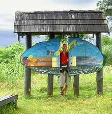
  • Datumsgrenzstein
  • Rainbow Reef
  • Waitavala Wasserrutsche
  • Lavena Coastal Walk
  • Vuna Blow Holes

Weblinks

 Commons: Taveuni – Sammlung von Bildern, Videos und Audiodateien
Der 180°-Meridian
"Zwischen gestern und heute"

Wikimedia Foundation.

Игры ⚽ Поможем сделать НИР

Schlagen Sie auch in anderen Wörterbüchern nach:

  • Taveuni — es una isla de Fiyi, situada en División Norte. Por extensión, es la trercera a escala nacional, después de Viti Levu y de Vanua Levu. Tiene un área total de 435 km². Tiene cerca de 9.000 habitantes, de los cuales cerca de 75 % son… …   Wikipedia Español

  • Taveuni — Taveuni,   drittgrößte der Fidschiinseln, 435 km2, etwa 15 000 Einwohner (v. a. Melanesier); gebirgige Vulkaninsel (bis 1 241 m über dem Meeresspiegel), dicht bewaldet; Kopragewinnung …   Universal-Lexikon

  • Taveuni — Infobox Mountain Name= Taveuni Photo=TaveuniNASA.jpg Caption=NASA Space Shuttle image of Taveuni. Top of image is NW. Elevation= Convert|1241|m|ft|0|abbr=on Range= Location=Fiji Prominence =Convert|1241|m|ft|0|abbr=on Coordinates =… …   Wikipedia

  • Taveuni F.C. — Football club infobox clubname = Taveuni F.C. fullname = Taveuni Football Club nickname = founded = 1947 ground = capacity = | chairman = manager = league = season = position = pattern la1=|pattern b1=|pattern ra1=… …   Wikipedia

  • Taveuni — 16° 49′ 00″ S 179° 58′ 00″ E / 16.816667, 179.966667 …   Wikipédia en Français

  • Taveuni Island Resort & Spa — (Matei,Фиджи) Категория отеля: 5 звездочный отель Адрес: Matei, 00000 Ma …   Каталог отелей

  • Taveuni Island Airport — is an airport in Matei on the northern part of Taveuni Island in Fiji airport codes|TVU|NFNM. The airport is quite small but receives a number of flights from SunAir and Air Fiji from Nadi and Suva. The airport is quite close to a number of… …   Wikipedia

  • Taveuni Island (Fiji) — Hotels: Garden Island Resort (Taveuni Island) …   International hotels

  • Taveuni beetle — Taxobox name = Taveuni beetle regnum = Animalia phylum = Arthropoda classis = Insecta ordo = Coleoptera subordo = Polyphaga familia = Cerambycidae subfamilia = Prioninae genus = Xixuthrus species = X. terribilis binomial = Xixuthrus terribilis… …   Wikipedia

  • Taveuni Island — ▪ island, Fiji       third largest island of Fiji, South Pacific Ocean. The island has an area of 168 square miles (435 square km). It lies off the southeast coast of Vanua Levu and was sighted by the Dutch navigator Abel Janszoon Tasman in 1643 …   Universalium

Share the article and excerpts

Direct link
Do a right-click on the link above
and select “Copy Link”