Tayum

Tayum
Municipality of Tayum
Lage von Tayum in der Provinz Abra
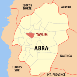
Karte
Basisdaten
Bezirk: Regierungsbezirk Cordillera
Provinz: Abra
Barangays: 11
Distrikt: 1. Distrikt von Abra
PSGC: 140124000
Einkommensklasse: 5. Einkommensklasse
Haushalte: 2439
Zensus 1. Mai 2000
Einwohnerzahl: 13.360
Zensus 1. August 2007
Bevölkerungsdichte: 312,9 Einwohner je km²
Fläche: 42,7 km²
Koordinaten: 17° 37′ N, 120° 39′ O17.619166666667120.65444444444Koordinaten: 17° 37′ N, 120° 39′ O
Postleitzahl: 2803
Geographische Lage auf den Philippinen
Tayum (Philippinen)
Tayum
Tayum

Tayum ist eine philippinische Stadtgemeinde in der Provinz Abra. Sie hat 12.539 Einwohner in 2439 Haushalten (Zensus 2000).

Baranggays

Tayum ist politisch unterteilt in elf Baranggays.

  • Bággalay
  • Básbasa
  • Budac
  • Bumagcat
  • Cabaroan
  • Deet
  • Gáddani
  • Patucannay
  • Pias
  • Poblacion
  • Velasco

Wikimedia Foundation.

Игры ⚽ Поможем сделать НИР

Schlagen Sie auch in anderen Wörterbüchern nach:

  • Tayum — Localisation de Tayum (en rouge) dans la province d Abra. Administration Pays …   Wikipédia en Français

  • Tayum — Original name in latin Tayum Name in other language Tayum State code PH Continent/City Asia/Manila longitude 17.6172 latitude 120.6542 altitude 65 Population 2530 Date 2011 07 31 …   Cities with a population over 1000 database

  • Tayum, Abra — Infobox Philippine municipality infoboxtitle = Municipality of Tayum sealfile = locatormapfile = Ph locator abra tayum.png caption = Map of Abra showing the location of Tayum. region = Cordillera Administrative Region province = Abra districts =… …   Wikipedia

  • Dolores, Abra — Dolores   Municipality   Seal …   Wikipedia

  • Bangued, Abra — Infobox Philippine municipality infoboxtitle = Municipality of Bangued sealfile = Ph seal abra bangued.png locatormapfile = Ph locator abra bangued.png caption = Map of Abra showing the location of Bangued. region = Cordillera Administrative… …   Wikipedia

  • Bangued — Municipality of Bangued Lage von Bangued in der Provinz Abra Basisdaten Bezirk: Regierungs …   Deutsch Wikipedia

  • Daguioman, Abra — Daguioman   Municipality   Seal …   Wikipedia

  • Danglas, Abra — Danglas   Municipality   Map of Abra showing the location of Danglas …   Wikipedia

  • Malibcong, Abra — Malibcong   Municipality   Map of Abra showing the location of Malibcong …   Wikipedia

  • Manabo, Abra — Manabo   Municipality   Seal …   Wikipedia

Share the article and excerpts

Direct link
Do a right-click on the link above
and select “Copy Link”