- Boliney
-
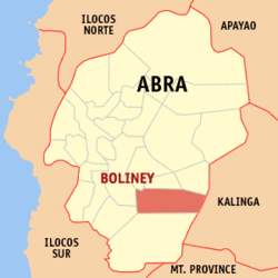
Municipality of Boliney Lage von Boliney in der Provinz Abra 
Basisdaten Bezirk: Regierungsbezirk Cordillera Provinz: Abra Barangays: 8 Distrikt: 1. Distrikt von Abra PSGC: 140102000 Einkommensklasse: 5. Einkommensklasse Haushalte: 639 Zensus 1. Mai 2000Einwohnerzahl: 3.349 Zensus 1. August 2007Bevölkerungsdichte: 19 Einwohner je km² Fläche: 176,40 km² Koordinaten: 17° 24′ N, 120° 48′ O17.4120.8Koordinaten: 17° 24′ N, 120° 48′ O Postleitzahl: 2815 Offizielle Webpräsenz: www.boliney.gov.ph Geographische Lage auf den Philippinen Boliney ist eine philippinische Stadtgemeinde in der Provinz Abra.
Inhaltsverzeichnis
Geografie
Boliney liegt im Norden der Insel Luzón etwa 345 km nördlich von Manila und etwa 50 km südöstlich von Bangued. Das Gebiet liegt 646 bis 2286 Meter über dem Meeresspiegel.
Boliney hat zwei ausgeprägte Jahreszeiten, eine Trockenzeit die von November bis April dauert und eine Regenzeit während des restlichen Jahres. Die durchschnittliche jährliche Niederschlagsmengen liegen bei 3100 mm bis 4100 mm, die Jahresdurchschnittstemperaturen liegen zwischen 25,5 °C und 28,8 °C.
Baranggays
Boliney ist politisch unterteilt in acht Baranggays.
- Amti
- Bao-yan
- Danac East
- Dao-angan
- Dumagas
- Kilong-Olao
- Poblacion (Boliney)
- Danac West
Bevölkerungsstruktur und -entwicklung
Die weitaus meisten Einwohner zählen zur Ethnie der Tinggian, daneben gibt es kleine Minderheiten von Bontok, Ilocano, Kalinga, Kankanaey, Kapampangan und Tagalog.
Wirtschaft und Infrastruktur
Zwei der acht Baranggay und etwa 1/6 aller Haushalte sind an das elektrische Stromnetz angeschlossen. Die Alphabetisierungsrate liegt bei 79.8%, insgesamt existieren 30 zumeist einklassige Schulen.
Sehenswürdigkeiten
- Bani Waterfalls, im Ort Bani etwa 32 km vom Hauptort Boliney entfernt
- Mt. Pusuey National Park
- Bani Hot Spring
Stadtgemeinden: Bangued | Boliney | Bucay | Bucloc | Daguioman | Danglas | Dolores | La Paz | Lacub | Lagangilang | Lagayan | Langiden | Licuan-Baay | Luba | Malibcong | Manabo | Peñarrubia | Pidigan | Pilar | Sallapadan | San Isidro | San Juan | San Quintin | Tayum | Tineg | Tubo | Villaviciosa
Wikimedia Foundation.

