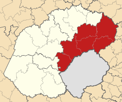
- Thabo Mofutsanyane
-
Thabo Mofutsanyane
Thabo Mofutsanyane District Municipality
Basisdaten Staat Südafrika Provinz Freistaat Sitz Witsieshoek Fläche 28.347 km² Einwohner 694.319 (24. Oktober 2007) Dichte 24,5 Einwohner pro km² Schlüssel DC19 ISO 3166-2 ZA-FS Politik Bürgermeister Mathokoana Mopedi Der Distrikt Thabo Mofutsanyane ist Teil der Provinz Freistaat in Südafrika. Auf einer Fläche von 28.347 km² leben 694.319 Einwohner (Stand: 24. Oktober 2007).[1] Die Hauptstadt ist Witsieshoek.[2]
Der Bezirk ist benannt nach Thabo Mofutsanyane, einem Anhänger des Anti-Apartheid-Kampfes. Er war der erste schwarze „Genosse“ nach der Öffnung der SACP (Südafrikanische Kommunistische Partei) für Schwarzafrikaner im Jahr 1952.[3]
Gemeinden mit ihren größten Städten
Als Beispiel für die Infrastruktur hier die Wasserversorgung der Haushalte (HWA = eigener Hauswasseranschluss; ÖWA = öffentlicher Wasseranschluss in der Nähe; KWA = kein Anschluss an ein Wasserleitungsnetz)[4]:
Gemeinde Verwaltungssitz Fläche Einwohner H W A Ö W A K W A Maluti a Phofung Witsieshoek 4.418 km² 360.779 8 % 84 % 8 % Setsoto Ficksburg 5.966 km² 123.186 7 % 80 % 13 % Dihlabeng Bethlehem 4.739 km² 128.918 13 % 74 % 13 % Phumelela Vrede 7.550 km² 50.897 7 % 73 % 20 % Nketoana Reitz 5.611 km² 61.941 7 % 78 % 15 % Nationalparks und Naturschutzgebiete
- Wolhuterskop Game and Nature Reserve
Einzelnachweise
- ↑ Community Survey 2007. Basic Results. Statistics South Africa, 24. Oktober 2007, abgerufen am 29. Juni 2010 (englisch)..
Hinweise zu den Daten (englisch). - ↑ Verwaltungsgrenzen Südafrika
- ↑ Namensbedeutung Gemeinden
- ↑ Gemeindestatistik Südafrika
Distrikte des südafrikanischen Freistaates (Vrystaat)Fezile Dabi | Lejweleputswa | Motheo | Thabo Mofutsanyane | Xhariep
Wikimedia Foundation.
Schlagen Sie auch in anderen Wörterbüchern nach:
Thabo Mofutsanyane District Municipality — Zamuni code=DC19 location=Free State area=? seat=Witsieshoek neighbours=Northern Free State to the north , Gert Sibande in Mpumalanga to the north east, Amajuba in Kwa Zulu Natal to the east, Uthukela to the south east, Lesotho (south), Motheo to … Wikipedia
Thabo — may refer to:People*Thabo Mbeki, president of South Africa *Thabo Makgoba, Anglican archbishop *Thabo Sefolosha, basketball player *Thabo Mooki, footballerPlaces*Thabo Mofutsanyane District Municipality in South Africa … Wikipedia
Liste der Gemeinden in der Provinz Freistaat — Die Provinz Freistaat mit eingezeichneten Distrikten und Gemeinden Die Liste der Gemeinden in der Provinz Freistaat führt alle Gemeinden (Local Municipalities) in der südafrikanischen Provinz Freistaat auf. Die Provinz Freistaat ist in 5… … Deutsch Wikipedia
Free State — Vrystaat Freistaat Wappen Basisdaten Hauptstadt: Bloemfontein Fläche: Rang: in % Südafrikas … Deutsch Wikipedia
Free State Provinz — Free State Vrystaat Freistaat Wappen Basisdaten Hauptstadt: Bloemfontein Fläche: Rang: in % Südafrikas … Deutsch Wikipedia
Oranje Freestate — Free State Vrystaat Freistaat Wappen Basisdaten Hauptstadt: Bloemfontein Fläche: Rang: in % Südafrikas … Deutsch Wikipedia
Liste der Gemeinden Südafrikas — Dies ist eine Liste der südafrikanischen Gemeinden. Inhaltsverzeichnis 1 Metropolgemeinden 2 Freistaat 2.1 Xhariep – Xhariep District Municipality (DC16) 2.2 … Deutsch Wikipedia
Dihlabeng Local Municipality — Local municipality Location … Wikipedia
Nketoana Local Municipality — Local municipality Location in … Wikipedia
Dihlabeng — Local Municipality Basisdaten … Deutsch Wikipedia
