- Motheo
-
Motheo
Motheo District Municipality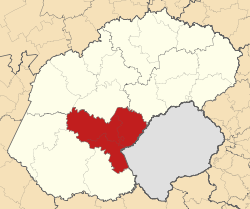
Symbole Wappen
Basisdaten Staat Südafrika Provinz Freistaat Sitz Bloemfontein Fläche 13.997,5 km² Einwohner 837.378 (24. Oktober 2007) Dichte 59,8 Einwohner pro km² Schlüssel DC17 ISO 3166-2 ZA-FS Webauftritt www.motheo.co.za (englisch) Politik Bürgermeister Evah Moilwa -29.11666666666726.216666666667Koordinaten: 29° 7′ S, 26° 13′ ODer Distrikt (District Municipality) Motheo ist Teil der Provinz Freistaat in Südafrika. Auf einer Fläche von 13.997 km² leben 837.378 Einwohner (Stand: 24. Oktober 2007).[1] Die Hauptstadt ist Bloemfontein.[2] Der Distriktname ist das Sesotho-Word für Grundstein. [3]
Gemeindestruktur
Als Beispiel für die Infrastruktur hier die Wasserversorgung der Haushalte (HWA = eigener Hauswasseranschluss; ÖWA = öffentlicher Wasseranschluss in der Nähe; KWA = kein Anschluss an ein Wasserleitungsnetz) [4]:
Gemeinde Verwaltungssitz Fläche Einwohner H W A Ö W A K W A Naledi Dewetsdorp 3.424 km² 27.471 7 % 78 % 15 % Mantsopa Ladybrand 4.291 km² 55.334 10 % 73 % 17 % Mangaung Bloemfontein 6.284 km² 645.430 13 % 82 % 5 % Nationalparks und Naturschutzgebiete
- Franklin Nature Reserve
- Caledon Nature Reserve
Einzelnachweise
- ↑ Community Survey 2007. Basic Results. Statistics South Africa, 24. Oktober 2007, abgerufen am 29. Juni 2010 (englisch)..
Hinweise zu den Daten (englisch). - ↑ Verwaltungsgrenzen Südafrika
- ↑ Namensbedeutung Gemeinden
- ↑ Gemeindestatistik Südafrika
Fezile Dabi | Lejweleputswa | Motheo | Thabo Mofutsanyane | Xhariep

Wikimedia Foundation.