- Lejweleputswa
-
Lejweleputswa
Lejweleputswa District Municipality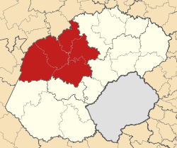
Basisdaten Staat Südafrika Provinz Freistaat Sitz Welkom Fläche 31.929,2 km² Einwohner 639.650 (24. Oktober 2007) Dichte 20 Einwohner pro km² Schlüssel DC18 ISO 3166-2 ZA-FS Webauftritt www.lejwe.co.za (englisch) Politik Bürgermeister Mathabo Leeto -27.96666666666726.733333333333Koordinaten: 27° 58′ S, 26° 44′ ODer Distrikt (District Municipality) Lejweleputswa ist Teil der Provinz Freistaat in Südafrika. Auf einer Fläche von 31.929 km² leben 639.650 Einwohner (Stand: 24. Oktober 2007).[1] Die Hauptstadt ist Welkom. [2] Der Name des Bezirkes ist das Sesotho-Word für die Goldfelder.[3]
Gemeindestruktur
Als Beispiel für die Infrastruktur hier die Wasserversorgung der Haushalte (HWA = eigener Hauswasseranschluss; ÖWA = öffentlicher Wasseranschluss in der Nähe; KWA = kein Anschluss an ein Wasserleitungsnetz) [4]:
Gemeinde Verwaltungssitz Fläche Einwohner H W A Ö W A K W A Masilonyana Theunissen 6.796 km² 64.399 10% 79% 11% Tokologo Boshof 9.326 km² 32.448 10% 67% 24% Tswelopele Bultfontein 6.524 km² 56.777 7% 75% 18% Nala Bothaville 4.129 km² 98.254 10% 79% 11% Matjhabeng Welkom 5.156 km² 408.159 13% 81% 6% Nationalparks/Naturschutzgebiete
- Willem Pretorius Nature Reserve
- Erfenis Nature Reserve
- Sandveld Nature Reserve
- Soetdoring Nature Reserve
Einzelnachweise
- ↑ Community Survey 2007. Basic Results. Statistics South Africa, 24. Oktober 2007, abgerufen am 29. Juni 2010 (englisch)..
Hinweise zu den Daten (englisch). - ↑ Verwaltungsgrenzen Südafrika
- ↑ Namensbedeutung Gemeinden
- ↑ Gemeindestatistik Südafrika
Distrikte des südafrikanischen Freistaates (Vrystaat)Fezile Dabi | Lejweleputswa | Motheo | Thabo Mofutsanyane | Xhariep
Wikimedia Foundation.
Schlagen Sie auch in anderen Wörterbüchern nach:
Lejweleputswa District Municipality — Lejweleputswa (Sesotho; English Gray rock ) is one of the 5 districts of Free State province of South Africa. The seat of Lejweleputswa is Welkom. The majority of its 657 019 people speak Sotho (2001 Census). The district code is… … Wikipedia
Lejweleputswa District Municipality — Admin ASC 2 Code Orig. name Lejweleputswa District Municipality Country and Admin Code ZA.03.DC18 ZA … World countries Adminstrative division ASC I-II
Free State — Vrystaat Freistaat Wappen Basisdaten Hauptstadt: Bloemfontein Fläche: Rang: in % Südafrikas … Deutsch Wikipedia
Free State Provinz — Free State Vrystaat Freistaat Wappen Basisdaten Hauptstadt: Bloemfontein Fläche: Rang: in % Südafrikas … Deutsch Wikipedia
Oranje Freestate — Free State Vrystaat Freistaat Wappen Basisdaten Hauptstadt: Bloemfontein Fläche: Rang: in % Südafrikas … Deutsch Wikipedia
Liste der Gemeinden in der Provinz Freistaat — Die Provinz Freistaat mit eingezeichneten Distrikten und Gemeinden Die Liste der Gemeinden in der Provinz Freistaat führt alle Gemeinden (Local Municipalities) in der südafrikanischen Provinz Freistaat auf. Die Provinz Freistaat ist in 5… … Deutsch Wikipedia
Liste der Gemeinden Südafrikas — Dies ist eine Liste der südafrikanischen Gemeinden. Inhaltsverzeichnis 1 Metropolgemeinden 2 Freistaat 2.1 Xhariep – Xhariep District Municipality (DC16) 2.2 … Deutsch Wikipedia
Masilonyana Local Municipality — Local municipality Loc … Wikipedia
Matjhabeng Local Municipality — Local municipality Locati … Wikipedia
Nala Local Municipality — Local municipality Location in the … Wikipedia
Lejweleputswa

18+
© Academic, 2000-2025
- Kontaktieren Sie uns: Unterstützung, Werbung
Wörterbücher Export, schritte mit PHP, Joomla, Drupal, WordPress, MODx.