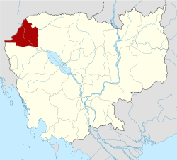
- Banteay Meanchey
-
Banteay Meanchey 
Kurzübersicht Hauptstadt Sisophon Fläche 6.679 km² Bevölkerung 577.772 (1998) Vorwahl 054 ISO 3166-2 KH-1 Die Provinz Bantey Meanchey (Khmer: Bântéay Méancheăy បន្ទាយមានជយ; IPA: [ɓɑntiːə̯j miːə̯nceə̯j]) liegt im Nordwesten von Kambodscha und grenzt somit an Thailand. Die Provinzhauptstadt heißt Sisophon.
Die Provinz ist in acht Bezirke unterteilt:
- Mongkol Borey
- Phnum Srok
- Preah Netr Preah
- Ou Chrov
- Serei Saophoan
- Thma Pouk
- Svay Chek
- Malai
Provinzen KambodschasProvinzen:
Banteay Meanchey | Battambang | Kampong Cham | Kampong Chhnang | Kampong Speu | Kampong Thom | Kampot | Kandal | Koh Kong | Kratie | Mondulkiri | Oddar Meanchey | Pursat | Preah Vihear | Prey Veng | Ratanakkiri | Siem Reap | Stung Treng | Svay Rieng | TakeoStädte mit Provinzstatus:
Kep | Pailin | Phnom Penh | Sihanoukville
Wikimedia Foundation.
Schlagen Sie auch in anderen Wörterbüchern nach:
Bântéay Méanchey — Banteay Mean Chey បន្ទាយមានជ Banteay Mean Chey Pays … Wikipédia en Français
Banteay Meanchey Province — Infobox Cambodian Province name = Banteay Meanchey khmer = បន្ទាយមានជ័យ area = 6,679 population = 577,772 population as of = 1998 density = 86.5 isocode = KH 1 capital = Sisophon districts = 8 communes = 64 villages = 624 | map Banteay Meanchey… … Wikipedia
Banteay Meanchey Province — Admin ASC 1 Code Orig. name Banteay Meanchey Province Country and Admin Code KH.25 KH … World countries Adminstrative division ASC I-II
Samraong, Banteay Meanchey (commune) — Infobox Commune Cambodia name= Samraong khmer= province=Banteay Meanchey district= Ou Chrov District population= population as of=1998 villages=10 geocode= Samraong is a khum (commune) of Ou Chrov District in Banteay Meanchey Province in north… … Wikipedia
Kampong Svay, Banteay Meanchey — for other uses see Kampong Svay Infobox Commune Cambodia name= Kampong Svay khmer= province=Banteay Meanchey district= Serei Saophoan District population= population as of=1998 communes= villages=5 geocode= Kampong Svay is a khum (commune) of… … Wikipedia
Banteay Meancheay — Banteay Meanchey Kurzübersicht Hauptstadt Sisophon Fläche 6.679 km² Bevölkerung … Deutsch Wikipedia
Meanchey District — is located in the southeastern part of Phnom Penh, Cambodia. The district is subdivided into 8 Sangkats and 30 Kroms. The district has an area of 43.79 km². According to the 1998 census of Cambodia, it had a population of 157,112.[1] Postal… … Wikipedia
Banteay Chhmar — Infobox Commune Cambodia name=Banteay Chhmar khmer= province=Banteay Meanchey district= Serei Saophoan District population= population as of=1998 communes= villages=14 geocode= Banteay Chhmar is a commune (khum) and a large temple complex in in… … Wikipedia
Banteay Neang — Infobox Commune Cambodia name=Banteay Neang khmer= province=Banteay Meanchey district= Mongkol Borei District population= population as of=1998 communes= villages=18 geocode=010201 Banteay Neang is a khum (commune) of Mongkol Borei District in… … Wikipedia
Banteay Chhmar — 14.071111111111103.10916666667 Koordinaten: 14° 4′ N, 103° 7′ O … Deutsch Wikipedia
