Thornbury (South Gloucestershire)
- Thornbury (South Gloucestershire)
-
51.6125-2.5202777777778
Thornbury ist eine Kleinstadt in South Gloucestershire. Sie liegt 18 km nördlich von Bristol und hat ca. 12.000 Einwohner.
Die Geschichte Thornburys reicht zurück bis in das 9. Jahrhundert. Die erste Siedlung hieß Thornbyrig und wird erstmals 896 erwähnt; im Domesday Book (1086) ist der Ort als Turneberie mit 103 Einwohnern verzeichnet. Jüngste Funde römischer Münzen lassen vermuten, dass der Ort schon 300 n. Chr. bestand.
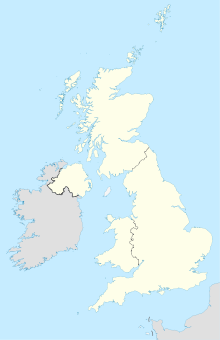
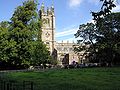
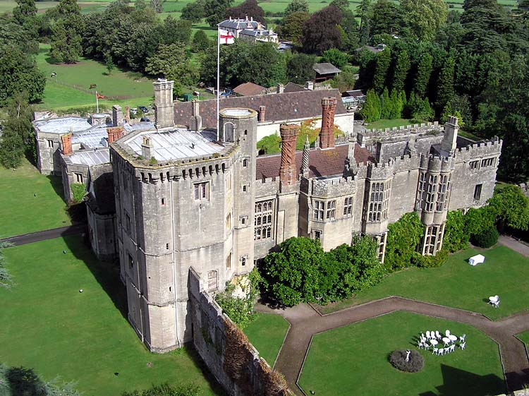
Zu den Sehenswürdigkeiten der Stadt gehört das Thornbury Castle, mit dessen Bau für Edward Stafford, 3. Herzog von Buckingham, 1511 begonnen wurde. 1521 wurde Edward Stafford hingerichtet, die Bauarbeiten wurden abgebrochen und das Gebäude wurde nicht vollendet. Gleichwohl wurde es 1535 von König Heinrich VIII. und seiner Ehefrau Anne Boleyn genutzt, später von Mary Tudor. Heute ist das Castle ein Hotel. Das älteste erhaltende Gebäude Thornburys ist die Kirche Saint Mary the Virgin, mit deren Bau 1340 begonnen wurde.
Thornbury unterhält eine Städtepartnerschaft mit Bockenem (Niedersachsen).
-
Die Kirche Saint Mary the Virgin
-
Weblinks
Wikimedia Foundation.
Schlagen Sie auch in anderen Wörterbüchern nach:
Thornbury, South Gloucestershire — infobox UK place country = England latitude= 51.6094longitude= 2.5249official name= Thornbury population= 12,000 unitary england= South Gloucestershire lieutenancy england=Gloucestershire region= South West Englandconstituency westminster=… … Wikipedia
South Gloucestershire — is a unitary district in the ceremonial county of Gloucestershire in South West England.The district was created in 1996, when the county of Avon was abolished, by the merger of former area of the districts of Kingswood and Northavon. The… … Wikipedia
South Gloucestershire — District Status Unitary Authority, District Region South West England Zerem. Grafschaft Gloucestershire … Deutsch Wikipedia
South Gloucestershire — Gloucestershire du Sud Statut Autorité unitaire Géographie Pays … Wikipédia en Français
South Gloucestershire (UK Parliament constituency) — UK former constituency infobox Name = South Gloucestershire Type = Borough Year = 1950 Abolition = 1983 members = oneSouth Gloucestershire was a parliamentary constituency in Gloucestershire. It returned one Member of Parliament to the House of… … Wikipedia
South Gloucestershire — ▪ unitary authority, England, United Kingdom unitary authority, geographic and historic county of Gloucestershire, southwestern England, directly north and east of the city of Bristol. South Gloucestershire is mainly a fertile clay valley… … Universalium
Downend, South Gloucestershire — Coordinates: 51°29′41″N 2°30′18″W / 51.4947°N 2.5049°W / 51.4947; 2.5049 … Wikipedia
Cheswick, South Gloucestershire — For the village in Northumberland, see Cheswick. Coordinates: 51°29′53″N 2°33′36″W / 51.498°N 2.56°W / 51.498; 2.5 … Wikipedia
Over, South Gloucestershire — This article is about the village in South Gloucestershire near Bristol. For the village in central Gloucestershire near Gloucester, see Over, Gloucestershire. Coordinates: 51°32′24″N 2°35′46″W / … Wikipedia
Codrington, South Gloucestershire — Coordinates: 51°30′43″N 2°23′38″W / 51.512°N 2.394°W / 51.512; 2.394 Codrington is a settlement in … Wikipedia