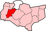
Tonbridge and Malling

Tonbridge and Malling
Borough of Tonbridge and Malling
Tonbridge and Malling
Lage in Kent
Status Borough
Region South East England
Verw.grafschaft Kent
Verwaltungssitz West Malling
Fläche 240,13 km² (175.)
Einwohner 115.700 (183.)
ONS-Code 29UP
Website www.tmbc.gov.uk

Tonbridge and Malling ist ein Verwaltungsbezirk mit dem Status eines Borough in der Grafschaft Kent in England. Er umfasst ein Gebiet, das von den North Downs im Norden bis zur Stadt Tonbridge im Süden reicht, in Richtung Nordosten wird er vom Fluss Medway durchflossen. Verwaltungssitz ist West Malling; weitere bedeutende Orte sind Aylesford, Burham, East Peckham, Hadlow, Hildenborough, Kings Hill, Snodland und Tonbridge.

Der Bezirk wurde am 1. April 1974 gebildet und entstand aus der Fusion des Urban District Tonbridge, des Rural District Malling und eines Teils des Rural District Tonbridge.


Wikimedia Foundation.

Игры ⚽ Поможем написать реферат

Schlagen Sie auch in anderen Wörterbüchern nach:

  • Tonbridge and Malling — is a local government district and borough in the English county of Kent.Tonbridge and Malling borough covers an area from the North Downs at Burham and Snodland in the north to the town of Tonbridge in the south. The River Medway flows in a… …   Wikipedia

  • Tonbridge and Malling — Distrito del Reino Unido Ubicación en el condado de …   Wikipedia Español

  • Tonbridge and Malling local elections — Tonbridge and Malling Council is elected every four years.Political controlConservative 1973 1995No overall control 1995 2003Conservative 2003 presentCouncil electionsTonbridge and Malling Council election 1999Tonbridge and Malling Council… …   Wikipedia

  • Tonbridge and Malling (UK Parliament constituency) — UK constituency infobox Name = Tonbridge and Malling Map1 = TonbridgeMalling Map2 = Kent Entity = Kent Type = County Year = 1974 County =Kent EP = South East England MP = John Stanley Party = ConservativeTonbridge and Malling is a constituency… …   Wikipedia

  • Tonbridge and Malling — ▪ district, England, United Kingdom       borough (district), administrative and historic county of Kent, England, on the River Medway southeast of London. It lies to the south of the North Downs and northeast of the Weald in west central Kent.… …   Universalium

  • Tonbridge et Malling (borough) — Borough de Tonbridge et Malling District dans le Kent Géographie Status: Borough Région: Angleterre du Sud Est Comté …   Wikipédia en Français

  • Tonbridge (UK Parliament constituency) — Tonbridge was a parliamentary constituency in Kent, centred on the town of Tonbridge. It returned one Member of Parliament to the House of Commons of the Parliament of the United Kingdom.It was abolished for the February 1974 general election,… …   Wikipedia

  • Tonbridge — infobox UK place country = England official name= Tonbridge static static image caption=Tonbridge Castle latitude= 51.1987 longitude= 0.2764 population = 30,340 (2007) shire district= Tonbridge and Malling shire county = Kent region= South East… …   Wikipedia

  • Tonbridge School — Not to be confused with Tonbridge Grammar School. Tonbridge School Motto Deus Dat Incrementum (God Giveth the Increase) Established 1553 Type public school …   Wikipedia

  • Tonbridge railway station — Infobox UK station name = Tonbridge code = TON manager = Southeastern locale = Tonbridge borough = Tonbridge and Malling years = 26 May 1842 events = Opened as Tunbridge years1 = January 1852 events1 = Renamed (Tunbridge Junction) years2 = 1864… …   Wikipedia

Share the article and excerpts

Direct link
Do a right-click on the link above
and select “Copy Link”