Barossa Council

Barossa Council
The Barossa Council
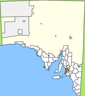
Australia-Map-SA-LGA-Barossa.png
Lage des Barossa Council in South Australia
Gliederung
Staat: Australien Australien
Bundesstaat: Flag of South Australia.svg South Australia
Verwaltungssitz: Nuriootpa
Daten und Zahlen
Fläche: 912 km²
Einwohner: 20.546 (2006) [1]
Bevölkerungsdichte: 23 Einwohner je km²
-34.5139.05

Der District Council of Barossa ist ein lokales Verwaltungsgebiet (LGA) im australischen Bundesstaat South Australia. Das Gebiet ist 912 km² groß und hat etwa 21.000 Einwohner.

Barossa liegt in der Region Outer Adelaide und grenzt im Südwesten an die Metropole Adelaide. Das Gebiet beinhaltet 47 Ortsteile und Ortschaften (alphabetisch): Altona, Angaston, Argent Town, Bald Hill, Barossa, Barossa Goldfields, Barossa Reservoir, Barossa Valley, Bethany, Bilyara, Cockatoo Valley, Collingrove, Concordia, Craneford, Cromer, Dorrien, Eden Valley, Flaxman Valley, Kalbeeba, Krondorf, Langmeil, Light Pass, Lone Pine, Lyndoch, Moculta, Mount Crawford, Mount Kitchener, Mount McKenzie, Mount Pleasant, Nuriootpa, Parrot Hill, Penrice, Pewsey Vale, Rocky Gully, Rosedale, Rowland Flat, Sandy Creek, South Para Reservoir, Springton, Stockwell, Tanunda, Tarawatta, Taunton, Vine Vale, Warren Reservoir, Williamstown und Wilton.

Der Verwaltungssitz des Councils befindet sich in der Ortschaft Nuriootpa im Norden der LGA, die etwa 4400 Einwohner hat.

Verwaltung

Der Council von Barossa hat 14 Mitglieder, die 13 Councillor und der Vorsitzende und Mayor (Bürgermeister) des Councils werden von den Bewohnern der LGA gewählt. Barossa ist nicht in Bezirke untergliedert.

Weblinks

Einzelnachweise

  1. Australian Bureau of Statistics (25. Oktober 2007): Barossa (DC) (Local Government Area) (Englisch). 2006 Census QuickStats. Abgerufen am 6. April 2010.

Wikimedia Foundation.

Игры ⚽ Нужен реферат?

Schlagen Sie auch in anderen Wörterbüchern nach:

  • Barossa Council — Infobox Australian Place | type = lga name = Barossa District Council state = sa caption = Location of the Barossa Council in blue pop = 20,386 (2004) density = 22.4 area = 912 est = 1996 seat = Angaston mayor = Brian Hurn region = Barossa Valley …   Wikipedia

  • Barossa Valley — Basisdaten Bundesstaat South Australia Geografische Lage …   Deutsch Wikipedia

  • Barossa Valley — The Barossa Valley is a major wine producing region and tourist destination of South Australia, located 60 km northeast of Adelaide. It is the valley formed by the North Para River, and the Barossa Valley Way is the main road through the valley,… …   Wikipedia

  • Bethany (Barossa Valley) — Barossa Valley Basisdaten Bundesstaat South Australia Geografische Lage …   Deutsch Wikipedia

  • Nuriootpa (Barossa Valley) — Barossa Valley Basisdaten Bundesstaat South Australia Geografische Lage …   Deutsch Wikipedia

  • Tanunda (Barossa Valley) — Barossa Valley Basisdaten Bundesstaat South Australia Geografische Lage …   Deutsch Wikipedia

  • Conseil de Barossa — 34° 30′ S 139° 03′ E / 34.5, 139.05 …   Wikipédia en Français

  • Light Regional Council — Infobox Australian Place | type = lga name = Light Regional Council state = sa caption = Location of Light Regional Council in blue pop = [http://www.abs.gov.au/ausstats/abs@census.nsf/4079a1bbd2a04b80ca256b9d00208f92/c2694854f21d09ebca256bc000145… …   Wikipedia

  • Adelaide Hills Council — Infobox Australian Place | type = lga name = Adelaide Hills Council state = sa caption = pop = 36,629 density = 46 area = 795.08 est = seat = Woodside mayor = region = Adelaide Hills, Metropolitan Adelaide url = http://www.ahc.sa.gov.au stategov …   Wikipedia

  • Mid Murray Council — South Australia Location of the Mid Murray Council in SA Population …   Wikipedia

Share the article and excerpts

Direct link
Do a right-click on the link above
and select “Copy Link”