Barrhead (Alberta)

Barrhead (Alberta)
Barrhead
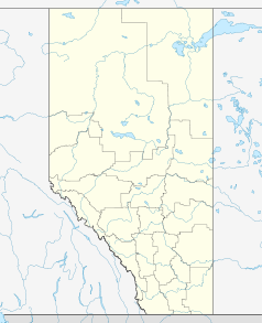
Lage in Alberta
Barrhead (Alberta)
Barrhead
Barrhead
Staat: Kanada
Provinz: Alberta
County: Barrhead County
Koordinaten: 54° 7′ N, 114° 24′ W54.12312-114.40179650Koordinaten: 54° 7′ N, 114° 24′ W
Höhe: 650 m
Fläche: 8,10 km²
Einwohner: 4209 (Stand: 2006)
Bevölkerungsdichte: 519,6 Einw./km²
Zeitzone: Mountain Time (UTC−7)
Postleitzahl: T7N
Webpräsenz: www.barrhead.ca

Barrhead ist eine Kleinstadt in Alberta, Kanada, die hauptsächlich von Landwirtschaft und Viehzucht lebt. Bedeutendere Wirtschaftszweige sind auch die Holzproduktion und die Firma Pollard Banknote Ltd, einer der größten Hersteller von Rubbellosen und Lotteriebedarf.[1]

Die Stadt ist benannt nach dem schottischen Ort Barrhead, dem Geburtsort eines frühen Siedlers, nämlich James McGuire. Sie liegt etwa 120km nördlich von der Provinzhauptstadt Edmonton, am Paddle River. In 16 km Entfernung befindet sich der Thunder Lake Provincial Park.

Demographie

2006 hatte die auf 650m Höhe gelegene Stadt eine Bevölkerung von 4.209, die sich auf 1.804 Haushalte verteilte. Bei einer Fläche von 8,10km² ergibt sich eine Bevölkerungsdichte von 519,7 Einwohnern pro Quadratkilometer.[2]

Weblinks

Quellen

  1. Pollard Banknote: Corporate Info (Abgerufen am 2. Dezember 2007)
  2. Statistics Canada: Barrhead (Abgerufen am 2. Dezember 2007)

Wikimedia Foundation.

Игры ⚽ Нужно решить контрольную?

Schlagen Sie auch in anderen Wörterbüchern nach:

  • Barrhead, Alberta — Infobox Settlement official name = Pagename other name = native name = nickname = settlement type = Town motto = imagesize = image caption = flag size = image seal size = image shield = shield size = city logo = citylogo size = mapsize = map… …   Wikipedia

  • Barrhead — Es gibt mehrere Orte mit Namen Barrhead: in Schottland, siehe Barrhead (Schottland) in der kanadischen Provinz Alberta, siehe Barrhead (Alberta) Diese Seite ist eine Begriffsklärung zur Unterscheidung mehrerer mit demselben Wort bezeichneter… …   Deutsch Wikipedia

  • Barrhead Airport — is located convert|1.7|NM|abbr=on|lk=in southwest of Barrhead, Alberta, Canada.References …   Wikipedia

  • Alberta Health Services — Type Health Care Industry Health care Founded May 2008 …   Wikipedia

  • Alberta general election, 2008 — 2004 ← members March 3, 2008 (2008 03 03) …   Wikipedia

  • Alberta Highway 22 — Highway 22 Cowboy Trail …   Wikipedia

  • Alberta provincial electoral districts — are currently single member ridings that each elect one member to the Legislative Assembly of Alberta. There are 83 current districts fixed in law in Alberta.HistoryThe original twenty five districts were drawn up by Liberal Member of Parliament… …   Wikipedia

  • Barrhead County No. 11, Alberta — County of Barrhead No. 11   Municipal district   …   Wikipedia

  • Alberta Highway 33 — Infobox road province=AB type=Hwy route = 33 alternate name = Grizzly Trail marker Text superimpose|align = left|x = 5|y = 23|base Text superimpose|align = left|x = 5|y = 23|base |base width = 40px|base caption = Highway 33|float text = 33|text… …   Wikipedia

  • Barrhead-Morinville-Westlock — Infobox Canada electoral district name =Barrhead Morinville Westlock province =Alberta caption =2004 boundaries prov rep =Ken Kowalski prov rep link = prov rep party =Progressive Conservative prov rep party link =Progressive Conservative… …   Wikipedia

Share the article and excerpts

Direct link
Do a right-click on the link above
and select “Copy Link”