- Tâmega (Subregion)
-
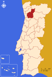
Lagekarte von TâmegaTâmega ist eine statistische Subregion Portugals und Teil der Região Norte. Sie wurde nach dem gleichnamigen Fluss benannt. Zum größten Teil besteht sie aus Gebieten des Distriktes Porto und wird durch einzelne Kreise der Distrikte Braga, Vila Real, Viseu und Aveiro komplettiert. Im Norden grenzen Ave und Alto Trás-os-Montes, im Osten Douro, im Süden Dão-Lafões und Entre Douro e Vouga und im Westen Grande Porto an die Subregion.
In Tamega mit einer Fläche von 2629 km² lebten 2001 551.301 Menschen.
Die Subregion besteht aus den folgenden 15 Kreisen:
- Amarante
- Baião
- Cabeceiras de Basto
- Castelo de Paiva
- Celorico de Basto
- Cinfães
- Felgueiras
- Lousada
- Marco de Canaveses
- Mondim de Basto
- Paços de Ferreira
- Paredes
- Penafiel
- Resende
- Ribeira de Pena

Região Norte (8): Alto Trás-os-Montes | Ave | Cávado | Douro | Entre Douro e Vouga | Grande Porto | Minho-Lima | Tâmega
Região Centro (12): Baixo Mondego | Baixo Vouga | Beira Interior Norte | Beira Interior Sul | Cova da Beira | Dão-Lafões | Médio Tejo | Oeste | Pinhal Interior Norte | Pinhal Interior Sul | Pinhal Litoral | Serra da Estrela
Região de Lisboa (2): Grande Lisboa | Península de Setúbal
Alentejo (5): Alentejo Central | Alentejo Litoral | Alto Alentejo | Baixo Alentejo | Lezíria do Tejo
Algarve (1): Algarve
Wikimedia Foundation.
Schlagen Sie auch in anderen Wörterbüchern nach:
Tâmega, Subregion — Tâmega is a Portuguese NUTS3 subregion, being a part of the NUTS2 region of Norte. Its name derives from the river Tâmega that crosses through the subregion. With 558,000 inhabitants (2005) it is the fourth most populated subregion in Portugal.… … Wikipedia
Tâmega (subregión) — TâmegaTâmega Región de Portugal Mapa … Wikipedia Español
Tâmega — Támega Der Tâmega in ChavesVorlage:Infobox Fluss/KARTE fehlt DatenVorlage:Infobox Fluss/GKZ fehlt … Deutsch Wikipedia
Támega — Der Tâmega in Chaves Der Tâmega (spanisch und galicisch Támega) ist ein ca. 145 km langer rechter bzw. nördlicher Nebenfluss des Douro in Nordportugal und Nordwestspanien. Er entspringt in 960 m Höhe in der Sierra de San Mamede nördlich der Stadt … Deutsch Wikipedia
Tâmega — La denominación de Tâmega puede ser: Tâmega Rio portugués. Tâmega Subregión estatística portuguesa, parte de la Região Norte. Fiães do Tâmega freguesia del concelho de Boticas. Vilela do Tâmega freguesia del concelho de Chaves. Sobretâmega… … Wikipedia Español
Cávado Subregion — Map showing the location of the Cávado subregion Cávado is a subregion that is integrated in the Portuguese region of Norte. It has 6 municipalities or Concelhos (in Portuguese) and is centered in the city of Braga (pop. 153,000). With an area of … Wikipedia
Douro (Subregion) — Lagekarte der Subregion Douro Douro ist eine statistische Subregion Portugals. Sie ist Teil der Região Norte, und setzt sich aus Kreisen der Distrikte Bragança, Vila Real, Viseu und Guarda zusammen. Im Norden grenzt die Subregion Alto Trás os… … Deutsch Wikipedia
Ave (Subregion) — Lage von Ave Die Region Ave ist eine statistische portugiesische Subregion und Teil der Região Norte. Während die Mehrzahl der Kreise zum Distrikt Braga gehören, sind Santo Tirso und Trofa dem Distrikt Porto zugeordnet. Im Norden grenzt Ave an… … Deutsch Wikipedia
Ave, Subregion — Ave is a subregion integrated in the larger Norte region in Portugal. Is bordered to the north by the subregion of Cávado, to the east and south by the subregion of Tâmega and to the west by the subregion of Grande Porto. It is a densely… … Wikipedia
Grande Porto Subregion — Map showing the location of the Grande Porto subregion Grande Porto or Greater Porto is a Portuguese NUTS3 subregion, integrating the NUTS2 region of Norte, in Portugal. It corresponds to 11 municipalities out of 16, the other 5 in Entre Douro e… … Wikipedia
Tâmega (Subregion)

18+
© Academic, 2000-2026
- Kontaktieren Sie uns: Unterstützung, Werbung
Wörterbücher Export, schritte mit PHP, Joomla, Drupal, WordPress, MODx.