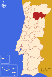
- Douro (Subregion)
-
Douro ist eine statistische Subregion Portugals. Sie ist Teil der Região Norte, und setzt sich aus Kreisen der Distrikte Bragança, Vila Real, Viseu und Guarda zusammen. Im Norden grenzt die Subregion Alto Trás-os-Montes, im Osten Spanien, im Süden Beira Interior Norte und Dão-Lafões und im Westen Tâmega an Douro.
Fläche: 4112 km². Bevölkerung (2001): 221.853.
Die Subregion besteht aus 19 Kreisen:
- Alijó
- Armamar
- Carrazeda de Ansiães
- Freixo de Espada à Cinta
- Lamego
- Mesão Frio
- Moimenta da Beira
- Penedono
- Peso da Régua
- Sabrosa
- Santa Marta de Penaguião
- São João da Pesqueira
- Sernancelhe
- Tabuaço
- Tarouca
- Torre de Moncorvo
- Vila Flor
- Vila Nova de Foz Côa
- Vila Real
Região Norte (8): Alto Trás-os-Montes | Ave | Cávado | Douro | Entre Douro e Vouga | Grande Porto | Minho-Lima | Tâmega
Região Centro (12): Baixo Mondego | Baixo Vouga | Beira Interior Norte | Beira Interior Sul | Cova da Beira | Dão-Lafões | Médio Tejo | Oeste | Pinhal Interior Norte | Pinhal Interior Sul | Pinhal Litoral | Serra da Estrela
Região de Lisboa (2): Grande Lisboa | Península de Setúbal
Alentejo (5): Alentejo Central | Alentejo Litoral | Alto Alentejo | Baixo Alentejo | Lezíria do Tejo
Algarve (1): Algarve
Wikimedia Foundation.
Schlagen Sie auch in anderen Wörterbüchern nach:
Douro Subregion — Map showing the location of the Douro subregion Douro Subregion is a part of Norte Region, Portugal that includes most of the Portuguese section of the Douro River. With an area of 4,114 km² and a population of 217,000, it is one of the less … Wikipedia
Douro, Subregion — Douro is a subregion in Portugal that is integrated in the region of Norte. The name derives from the fact that the subregion covers the major part of the Portuguese section of the river Douro.With an area of 4,114 km² and a population of 217,000 … Wikipedia
Douro — For the municipality in the Philippines, see Duero, Bohol. For the Spanish wine region, see Ribera del Duero. For the Portuguese wine region, see Douro DOC. For the Portuguese NUTS3 subregion, see Douro Subregion. Coordinates: 41°08′N 8°40′W … Wikipedia
Douro — Vorlage:Infobox Fluss/DGWK fehltVorlage:Infobox Fluss/KARTE fehlt Duero (port. Douro) Der Duero Daten Lage Spanien … Deutsch Wikipedia
Douro — Saltar a navegación, búsqueda Para el artículo sobre el río, véase Duero. Douro Región de Portugal Mapa … Wikipedia Español
Douro DOC — Alto Douro Wine Region * UNESCO World Heritage Site Terraced vineyards along the Douro river … Wikipedia
Douro Litoral Province — Former province of Douro Litoral Douro Litoral (Portuguese pronunciation: [ˈdowɾu lituˈɾaɫ]) is a historical province of Portugal. It is centered on the city of Porto, now the capital of the Norte Region. Other important cities in the… … Wikipedia
Donelo do Douro — ist ein Dorf in der Freguesia Covas do Douro im Norden Portugals und gehört zur Subregion Douro. Donelo erstreckt sich auf einer Fläche von 3 km² hat 112 Einwohner (2001) und liegt 7 km vom Duero entfernt. Wirtschaft Die Bevölkerung des Ortes… … Deutsch Wikipedia
Grande Porto Subregion — Map showing the location of the Grande Porto subregion Grande Porto or Greater Porto is a Portuguese NUTS3 subregion, integrating the NUTS2 region of Norte, in Portugal. It corresponds to 11 municipalities out of 16, the other 5 in Entre Douro e… … Wikipedia
Entre Douro e Vouga — Lagekarte von Entre Douro e Vouga Entre Douro e Vouga ist eine statistische Subregion Portugals. Sie ist Teil der Região Norte und des Distriktes Aveiro. Im Norden grenzen Grande Porto und Tâmega, im Osten Dão Lafões und im Süden und Westen Baixo … Deutsch Wikipedia

