- U.S. Highway 180
-

Karte 
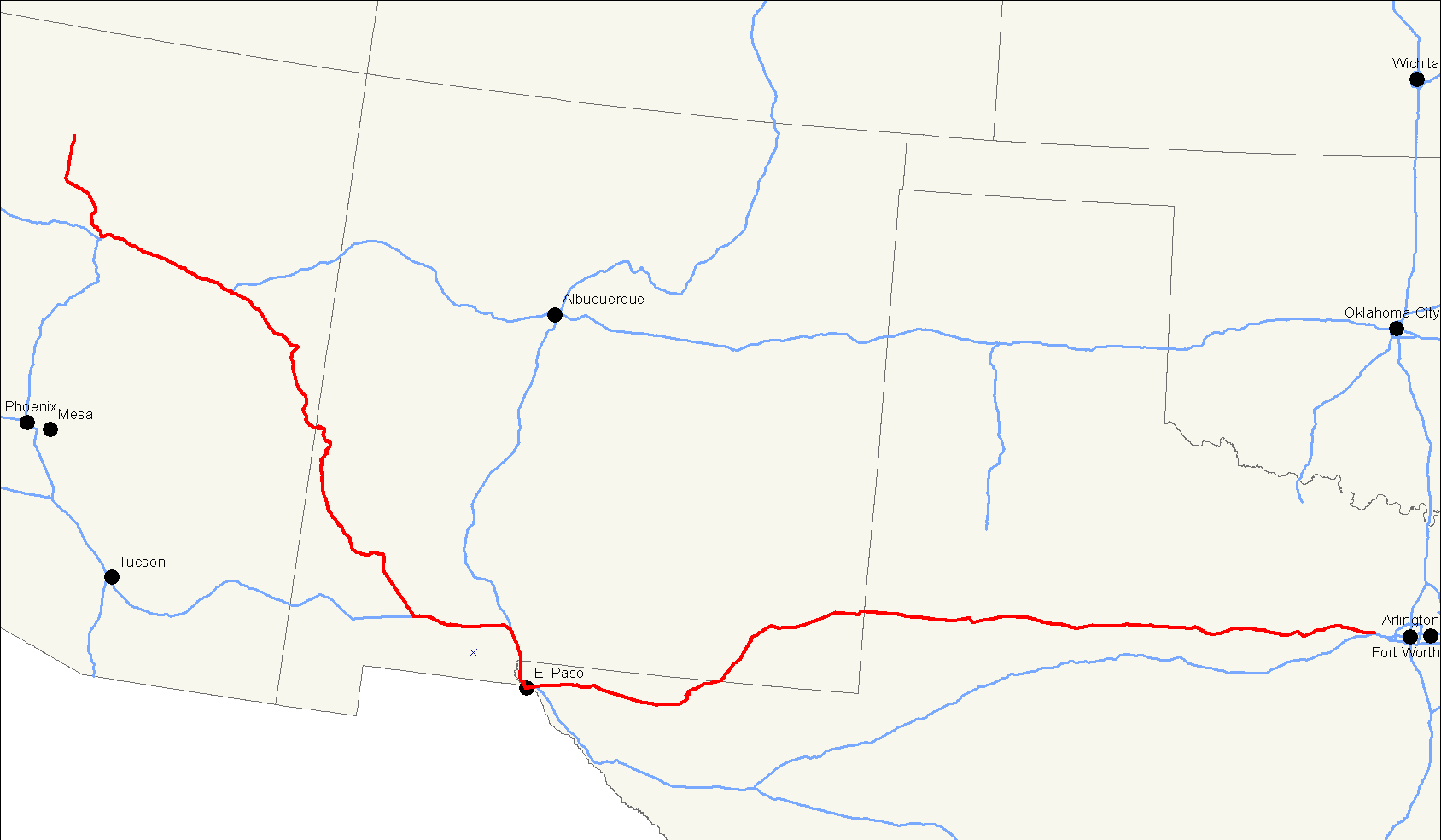
Basisdaten Gesamtlänge: 1092 mi/ 1757 km Eröffnung: 1926 Bundesstaaten: Arizona
New Mexico
TexasAnfangspunkt:  AZ 64 in Valle, AZ
Endpunkt:  I-20 in Hudson Oaks, TX
Der U.S. Highway 180 ist eine Ost-West Verbindung im Westen der Vereinigten Staaten. Er beginnt an der Arizona State Route 64 in Valle nahe dem Grand-Canyon-Nationalpark und endet an der Interstate 20 in Hudson Oaks in Texas. Auf seinem Weg liegen vier Nationalparks: der Grand-Canyon-Nationalpark, der Petrified-Forest-Nationalpark, der Guadalupe-Mountains-Nationalpark und der Carlsbad-Caverns-Nationalpark
Weblinks
- End of US Highways (englisch)

U.S. Highway 1 | 2 | 3 | 4 | 5 | 6 | 7 | 8 | 9 | 10 | 11 | 12 | 13 | 14 | 15 | 16 | 17 | 18 | 19 | 20 | 21 | 22 | 23 | 24 | 25 | 26 | 27 | 28 | 29 | 30 | 31 | 32 | 33 | 34 | 35 | 36 | 37 | 38 | 40 | 41 | 42 | 43 | 44 | 45 | 46 | 48 | 49 | 50 | 51 | 52 | 53 | 54 | 55 | 56 | 57 | 58 | 59 | 60 | 61 | 62 | 63 | 64 | 65 | 66 | 67 | 68 | 69 | 70 | 71 | 72 | 73 | 74 | 75 | 76 | 77 | 78 | 79 | 80 | 81 | 82 | 83 | 84 | 85 | 87 | 89 | 89A | 90 | 91 | 92 | 93 | 94 | 95 | 96 | 97 | 98 | 99 | 101 | 136 | 150 | 163 | 180 | 191 | 218 | 231 | 280 | 302 | 380 | 395 | 400 | 412 | 425
Wikimedia Foundation.
Schlagen Sie auch in anderen Wörterbüchern nach:
North Carolina Highway 180 — NC 180 Route information Maintained by NCDOT Length: 1 mi[1] … Wikipedia
Mexican Federal Highway 180 — Federal Highway 180 Carretera Federal 180 Carretera Federal 180 Major junctions Fr … Wikipedia
Texas State Highway 180 — Infobox TX State Highway type=State route=180 length mi=30.4 [http://www.dot.state.tx.us/ Texas Department of Transportation] (TXDOT) [http://www.dot.state.tx.us/tpp/hwy/sh/sh0180.htm State Highway No. 180] . Retrieved 29 October 2006.] length km … Wikipedia
Arkansas Highway 180 — Highway 180 Martin Luther King, Jr. Boulevard Route i … Wikipedia
Wisconsin Highway 180 — Infobox road state=WI type=WI route=180 length mi=30.42 length ref=cite web | last = Bessert | first = Chris | title =Wisconsin Highways: Highways 180 189 (Highway 180) | work =Wisconsin Highways | url… … Wikipedia
180 Degree Resorts — (Chamba,Индия) Категория отеля: Адрес: 7 Mile Stone,P.O Kanatal,Chamba Mussurri … Каталог отелей
Highway 97 (British Columbia) — British Columbia Highway 97 ist die längste, durchgehende Fernstraße in der Provinz British Columbia im Westen von Kanada. Highway 97 südlich von Fort Nelson Inhaltsverzeichnis 1 … Deutsch Wikipedia
Highway 417 (Ontario) — Infobox road state=ON type=Hwy route=417 alternate name=Queensway length km=181 length ref=Ministry of Transportation of Ontario, [http://www.raqsa.mto.gov.on.ca/techpubs/TrafficVolumes.nsf/tvweb 2004 Annual Average Daily Traffic] ] length… … Wikipedia
Highway 60 (Israel) — Highway 60 (Hebrew: כביש 60, Kvish Shishim ) is a north south intercity road in Israel and the West Bank that stretches from Beersheba to Nazareth.[citation needed] Contents … Wikipedia
Highway 105 (Ontario) — Infobox road province=ON type=Hwy route=105 alternate name= maint=the Ministry of Transportation length km= length ref=Ministry of Transportation of Ontario, [http://www.raqsa.mto.gov.on.ca/techpubs/TrafficVolumes.nsf/tvweb 2004 Annual Average… … Wikipedia
U.S. Highway 180

18+
© Academic, 2000-2024
- Kontaktieren Sie uns: Unterstützung, Werbung
Wörterbücher Export, schritte mit PHP, Joomla, Drupal, WordPress, MODx.