- U.S. Highway 280
-
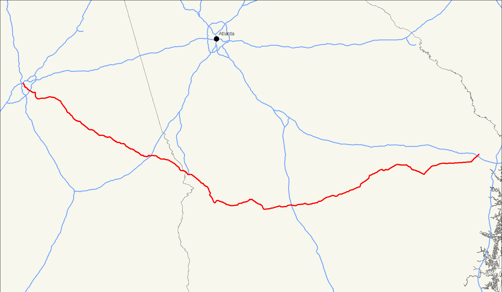
Karte 
Basisdaten Gesamtlänge: 392 mi/631 km Eröffnung: 1931 Bundesstaaten: Alabama
GeorgiaAnfangspunkt:  I-20
I-20  I-59
I-59  US 31 in Birmingham
Endpunkt:  US 80 im Bryan County
Der U.S. Highway 280 (kurz US 280) ist ein United States Highway in den Vereinigten Staaten. Der Highway beginnt an der Interstates 20 und 59 in Birmingham und endet am U.S. Highway 80 im Bryan County. Über lange Strecken verläuft die Straße durch dünnbesiedelte Gebiete und kleine Städte im Süden Georgias und Osten Alabamas. Im Talladega County ist der US 280 als Jim Nabors Highway bekannt.
Zwischen Columbus und dem Bryan County dient der U.S. Highway als Umgehungsstraße des U.S. Highways 80. Dies wird auch von der Nummer 280 symbolisiert.
Weblinks
- South East Roads (englisch)
- End of US Highways (englisch)

U.S. Highway 1 | 2 | 3 | 4 | 5 | 6 | 7 | 8 | 9 | 10 | 11 | 12 | 13 | 14 | 15 | 16 | 17 | 18 | 19 | 20 | 21 | 22 | 23 | 24 | 25 | 26 | 27 | 28 | 29 | 30 | 31 | 32 | 33 | 34 | 35 | 36 | 37 | 38 | 40 | 41 | 42 | 43 | 44 | 45 | 46 | 48 | 49 | 50 | 51 | 52 | 53 | 54 | 55 | 56 | 57 | 58 | 59 | 60 | 61 | 62 | 63 | 64 | 65 | 66 | 67 | 68 | 69 | 70 | 71 | 72 | 73 | 74 | 75 | 76 | 77 | 78 | 79 | 80 | 81 | 82 | 83 | 84 | 85 | 87 | 89 | 89A | 90 | 91 | 92 | 93 | 94 | 95 | 96 | 97 | 98 | 99 | 101 | 136 | 150 | 163 | 180 | 191 | 218 | 231 | 280 | 302 | 380 | 395 | 400 | 412 | 425
Wikimedia Foundation.
Schlagen Sie auch in anderen Wörterbüchern nach:
Minnesota State Highway 280 — Trunk Highway 280 Route information Defined by MS § 161.115(211) … Wikipedia
Minnesota State Highway 280 — Basisdaten Gesamtlänge: 4 mi/ 6 km Eröffnung: 1949 Bundesstaat: … Deutsch Wikipedia
North Carolina Highway 280 — NC 280 Route information Maintained by NCDOT Length: 18.16 mi[2] (29.23 km) … Wikipedia
Highway system of São Paulo — The highway system of São Paulo is the largest statewide road transportation system in Brazil, with 34,650 km. It consists of a hugely interconnected network of municipal (11,600 km), state (22,000 km) and federal (1,050 km) roads. More than 90%… … Wikipedia
List of highways numbered 280 — Route 280, or Highway 280, may refer to: Canada Manitoba Provincial Road 280 New Brunswick Route 280 United States Interstate 280 U.S. Route 280 … Wikipedia
U.S. Route 280 in Alabama — Infobox road state=AL type=US route=280 alternate name=State Route 38 length mi=141.256 length ref=Alabama Department of Transportation, [http://www.dot.state.al.us/NR/rdonlyres/7B15B300 359D 413A A7FA ED33C8C261CD/0/CountyMilePostMaps.pdf County … Wikipedia
North Carolina Highway 191 — NC 191 Route information Maintained by NCDOT Length: 21.62 mi[2] … Wikipedia
Minnesota State Route 280 — Basisdaten Gesamtlänge: 4 mi/ 6 km Eröffnung: 1949 … Deutsch Wikipedia
North Carolina Highway 146 — NC 146 Long Shoals Road Route information Maintained by NCDOT Length: 3.51 mi … Wikipedia
North Carolina Highway System — NC state route shields System information Notes: State roads maintained by the NCDOT with future toll roads managed by the NCTA … Wikipedia
U.S. Highway 280

18+
© Academic, 2000-2026
- Kontaktieren Sie uns: Unterstützung, Werbung
Wörterbücher Export, schritte mit PHP, Joomla, Drupal, WordPress, MODx.