U.S. Highway 380

U.S. Highway 380
Straßenschild des U.S. Highways 380
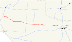
Karte
Karte des U.S. Highways 380
Basisdaten
Gesamtlänge:  673 mi/1083 km
Eröffnung:  1932
Bundesstaaten: New Mexico
Texas
Anfangspunkt:  Straßenschild der I-25 I-25 in San Antonio
Endpunkt:  Straßenschild der I-30 I-30 in Greenville

Der U.S. Highway 380 (kurz US 380) ist ein Ost-West United States Highway. Er beginnt an der Interstate 25 in San Antonio südlich von Socorro und endet in Greenville an der Interstate 30. Der Highway trifft im Verlauf nicht auf den U.S. Highway 80, obwohl sich die Nummer 380 von ihm ableitet. In Albany trifft er aber auf den U.S. Highway 180. Der U.S. Highway führt nördlich an den Städten Dallas und Fort Worth vorbei. Seit 2004 werden die östlichen drei bis vier Meilen zusammen mit dem U.S. Highway 69 als Umgehungsroute um Greenville genutzt.

Weblinks


Wikimedia Foundation.

Игры ⚽ Нужно решить контрольную?

Schlagen Sie auch in anderen Wörterbüchern nach:

  • Highway D5 — Infobox European road marker name=Via Carolina eroad= length km=151 starting terminus= junction= ending terminus= countries=Czech Republic regions=Praha, Central Bohemian Region, Pilsen Region cities=Prague, PilsenHighway D5 ( cs. Dálnice D5) is… …   Wikipedia

  • U.S. Route 380 — Infobox U.S. Route article route=380 length mi=673 length round=0 length ref= yrcom=1932 direction a=West from= junction= direction b=East to= spur of=80U.S. Route 380 is an east west United States highway. The highway s eastern terminus is in… …   Wikipedia

  • Texas State Highway 114 — Infobox TX State Highway type=State route=114 length mi=194.452 length ref=TxDOT|SH|114|accessdate=2008 03 15] length round=3 formed=by 1933 dir1=West dir2=East from=jct|state=NM|NM|114 junction=jct|state=TX|US|385 jct|state=TX|US|62|US|82… …   Wikipedia

  • Texas State Highway 283 — Infobox TX State Highway type=State route=283 length mi=11.784 length ref=TxDOT|SH|283|accessdate=2008 04 04] length round=3 formed=by 1939 dir1=West dir2=East from=jct|state=TX|US|380 junction= to=jct|state=TX|US|277 in Stamford previous… …   Wikipedia

  • U.S. Highway 54 — Karte …   Deutsch Wikipedia

  • U.S. Highway 80 — Karte …   Deutsch Wikipedia

  • Texas State Highway 6 — Infobox TX State Highway type=State route=6 length mi=476.4 length ref=TxDOT|SH|6|accessdate=2008 03 15] length round=1 formed=1939 dir1=South dir2=North from=jct|state=TX|I|45|TX|146 in La Marque junction=jct|state=TX|I|10 in Houston… …   Wikipedia

  • Texas State Highway 121 — Infobox TX State Highway type=State route=121 shields= length mi=85.56Texas Department of Transportation, [http://www.dot.state.tx.us/tpp/hwy/sh/sh0121.htm] ] length km=137.69 formed=by 1939 dir1=Southwest dir2=Northeast from= junction= |to=… …   Wikipedia

  • Hana Highway — The Hāna Highway (also known as the Hana Road or Road To Hana) is the name given to the 68 mile/109km long stretch of Hawaii State Highways 36 and 360 which connect the population center of Kahului with the town of Hāna in east Maui. On the east… …   Wikipedia

  • List of highways numbered 380 — The following highways are numbered 380: United States Interstate 380 U.S. Route 380 Arkansas Highway 380 …   Wikipedia

Share the article and excerpts

Direct link
https://de-academic.com/dic.nsf/dewiki/1424152 Do a right-click on the link above
and select “Copy Link”