Upper Klamath Lake

Upper Klamath Lake
Upper Klamath Lake
Das obere Einzugsgebiet des Klamath River
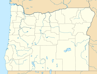
Geographische Lage Klamath County, Oregon, USA
Zuflüsse Williamson River u. a.
Abfluss Link RiverKlamath River
Größere Städte in der Nähe Klamath Falls
Daten
Koordinaten 42° 24′ N, 121° 53′ W42.392222222222-121.880277777781262Koordinaten: 42° 24′ N, 121° 53′ W
Upper Klamath Lake (Oregon)
Upper Klamath Lake
Höhe über Meeresspiegel 1.262 m
Länge 32 kmf6
Breite 12,9 kmf7
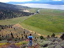
Der See von Klamath Falls aus betrachtet

Der Upper Klamath Lake (auch Klamath Lake) ist ein großer natürlicher Süßwassersee östlich der Kaskadenkette im südlichen Oregon, nordwestlich des Ortes Klamath Falls, zu Füßen des Aspen Butte. Er ist der letzte Überrest des pleistozänen Sees Lake Modoc und stellt heute das größte Süßwasserdepot des Pazifischen Nordwestens dar. Er liegt am Rand des Halbwüsten-Hochlandes Großes Becken auf einer Höhe von 1262 m und ist etwa 32 km lang und 12,9 km breit.

Sein Hauptzufluss ist der Williamson River. Das Wasser fließt in den Klamath River beziehungsweise je nach Definition den Link River im Süden ab. Nach Norden hin befindet sich ein kleiner Kanal in Richtung Agency Lake. Am Nordufer liegt auch das Upper Klamath National Wildlife Refuge.

Seit 1917 ist das Bureau of Reclamation für den See zuständig. Die Behörde sorgt im Rahmen des Klamath Reclamation Projects für die Bewässerung im Süden.

Weblinks


Wikimedia Foundation.

Игры ⚽ Поможем решить контрольную работу

Schlagen Sie auch in anderen Wörterbüchern nach:

  • Upper Klamath Lake — Infobox lake lake name = Upper Klamath Lake image lake = Wpdms shdrlfi020l upper klamath lake.jpg caption lake = image bathymetry = caption bathymetry = location = Oregon coords = coord|42|23|32|N|121|52|49|W|region:US OR… …   Wikipedia

  • Upper Klamath Lake — Sp Aukštutinis Klãmato ẽžeras Ap Upper Klamath Lake L JAV (Oregonas) …   Pasaulio vietovardžiai. Internetinė duomenų bazė

  • Upper Klamath Lake — Lac Klamath 42°23′32″N 121°52′49″O / 42.39222, 121.88028 …   Wikipédia en Français

  • Upper Klamath Lake — geographical name lake 30 miles (48 kilometers) long S Oregon SSE of Crater Lake drained by Klamath River see Lower Klamath Lake …   New Collegiate Dictionary

  • Upper Klamath Lake. — See under Klamath Lakes. * * * …   Universalium

  • Upper Klamath Lake. — See under Klamath Lakes …   Useful english dictionary

  • Lower Klamath Lake — Infobox lake lake name = Lower Klamath Lake image lake = LowerKlamathNWR 8199t.jpg caption lake = Freshwater marsh on Lower Klamath Lake image bathymetry = caption bathymetry = location = Siskiyou County, California coords = type = inflow =… …   Wikipedia

  • Lower Klamath Lake — geographical name lake N California on Oregon border SSE of Upper Klamath Lake (in Oregon) …   New Collegiate Dictionary

  • Lago Upper Klamath — (Upper Klamath Lake) Vista del lago Localización geográfica / administrativa …   Wikipedia Español

  • Klamath River — Der Klamath River in NordkalifornienVorlage:Infobox Fluss/KARTE fehlt Daten …   Deutsch Wikipedia

Share the article and excerpts

Direct link
Do a right-click on the link above
and select “Copy Link”