Voronoi-Interpolation

Voronoi-Interpolation

Die Voronoi-Interpolation (engl. natural neighbor interpolation „Interpolation durch natürliche Nachbarn“), auch Sibson-Interpolation genannt, ist ein Interpolationsverfahren, das mit Voronoi-Diagrammen arbeitet.

Prinzip

Gegeben sind Punkte in einem metrischen Raum und die ihnen zugewiesenen Werte. In den Raum soll ein zusätzlicher Punkt eingefügt werden. Sein Wert soll aus den umgebenden Punkten interpoliert werden.

Dazu wird zunächst aus den vorgegebenen Punkten das Voronoi-Diagramm erzeugt (s. Abb. 1). Anschließend wird der zusätzliche Punkt mit seiner Voronoi-Zelle eingefügt (s. Abb. 2).

Abb. 1. Voronoi-Diagramm. Die Kanten liegen jeweils exakt auf halbem Weg zwischen zwei Punkten.   Abb. 2. Die neue Zelle (rot) wird eingefügt. Die Überlappungsbereiche mit den alten Zellen (orange) dienen als Gewichtungsfaktoren.
Voronoi diagram.svg Voronoi-Interpolation.svg

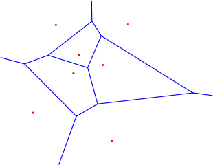
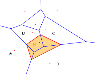
Der Wert des neuen Punktes ergibt sich nun, indem die Flächeninhalte der Überschneidungen mit den Nachbarzellen im Verhältnis zum Gesamtflächeninhalt der neuen Zelle als Gewichtungsfaktoren der Interpolation verwendet werden. Im Beispiel oben wäre das:

n = \frac{A ( A \cap N )}{A(N)} \cdot a + \frac{A( B \cap N )}{A(N)} \cdot b + \frac{A ( C \cap N )}{A(N)} \cdot c + \frac{A ( D \cap N )}{A(N)} \cdot d

wobei A(N) den Flächeninhalt einer Fläche N angibt, und a,b,c und d für die gegebenen Funktionswerte stehen.

Anwendung

Die Voronoi-Interpolation kann prinzipiell überall angewandt werden, wo in einem metrischen Raum Werte interpoliert werden sollen.

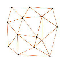
Ein Dreiecksnetz bildet die Oberfläche eines dreidimensionalen Objekts nach. Die Delaunay-Triangulation erzeugt Dreiecksnetze mit für die Computergrafik besonders günstigen Eigenschaften.

Dadurch, dass Voronoi-Diagramme eng mit der Delaunay-Triangulation verwandt sind, bietet sich die Voronoi-Interpolation insbesondere in der 3D-Computergrafik an. Sie kann dort verwendet werden, um ein bestehendes Dreiecksnetz durch Hinzufügen neuer Punkte zu verfeinern.


Wikimedia Foundation.

Игры ⚽ Поможем написать курсовую

Schlagen Sie auch in anderen Wörterbüchern nach:

  • Voronoi diagram — The Voronoi diagram of a random set of points in the plane (all points lie within the image). In mathematics, a Voronoi diagram is a special kind of decomposition of a given space, e.g., a metric space, determined by distances to a specified… …   Wikipedia

  • Nearest-neighbor interpolation — (blue lines) in one dimension on a (uniform) dataset (red points) …   Wikipedia

  • Clustan — ist eines der ältesten integrierten Statistik Programme zur Clusteranalyse und zum Data Mining. Die Anfänge gehen auf Fortran Programme aus dem Jahr 1968 zurück. David Wishart ist gleichzeitig der Entwickler und Chef der Firma Clustan Ltd aus… …   Deutsch Wikipedia

  • Variable régionalisée — La VR comme phénomène physique : topographie de la ville de Binche …   Wikipédia en Français

  • Glossaire du data mining — Exploration de données Articles principaux Exploration de données Fouille de données spatiales Fouille du web Fouille de flots de données Fouille de textes …   Wikipédia en Français

  • Natural neighbor — interpolation. The colored circles. which represent the interpolating weights, wi, are generated using the ratio of the shaded area to that of the cell area of the surrounding points. The shaded area is due to the insertion of the point to be… …   Wikipedia

  • Fouille de données spatiales — Exploration de données Articles principaux Exploration de données Fouille de données spatiales Fouille du web Fouille de flots de données Fouille de textes …   Wikipédia en Français

  • Projet:Mathématiques/Liste des articles de mathématiques — Cette page n est plus mise à jour depuis l arrêt de DumZiBoT. Pour demander sa remise en service, faire une requête sur WP:RBOT Cette page recense les articles relatifs aux mathématiques, qui sont liés aux portails de mathématiques, géométrie ou… …   Wikipédia en Français

  • Geoinformationssystem — Geoinformationssysteme (GIS), Geographische Informationssysteme oder Räumliche Informationssysteme (RIS) sind Informationssysteme zur Erfassung, Bearbeitung, Organisation, Analyse und Präsentation geografischer Daten. Geoinformationssysteme… …   Deutsch Wikipedia

  • Delaunay triangulation — A Delaunay triangulation in the plane with circumcircles shown In mathematics and computational geometry, a Delaunay triangulation for a set P of points in the plane is a triangulation DT(P) such that no point in P is inside the circumcircle of… …   Wikipedia

Share the article and excerpts

Direct link
Do a right-click on the link above
and select “Copy Link”