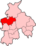
Wyre (Borough)

Wyre (Borough)
Borough of Wyre
Wyre
Lage in Lancashire
Status Borough
Region North West England
Verw.grafschaft Lancashire
Verwaltungssitz Poulton-le-Fylde
Fläche 282,55 km² (162.)
Einwohner 110.900 (197.)
ONS-Code 30UQ
Website www.wyrebc.gov.uk

Wyre ist ein Verwaltungsbezirk mit dem Status eines Borough in der Grafschaft Lancashire in England. Verwaltungssitz ist die Stadt Poulton-le-Fylde; weitere bedeutende Orte sind Catterall, Fleetwood, Garstang, Great Eccleston, Pilling, Preesall und Thornton Cleveleys.

Der Bezirk wurde am 1. April 1974 gebildet und entstand aus der Fusion des Municipal Borough Fleetwood, der Urban Districts Poulton-le-Fylde, Preesall und Thornton-Cleeveleys sowie des Rural District Garstang.

Weblinks

 Commons: Wyre – Sammlung von Bildern, Videos und Audiodateien

Wikimedia Foundation.

Игры ⚽ Нужно решить контрольную?

Schlagen Sie auch in anderen Wörterbüchern nach:

  • Wyre (disambiguation) — Wyre may be:* Wyre borough, a district in Lancashire, England ** the River Wyre after which it is named * Wyre Forest (district) in Worcestershire, England ** Wyre Forest after which it is named * Afon Wyre (Welsh for River Wyre ), a river in… …   Wikipedia

  • Wyre — Infobox UK District name = Borough of Wyre status = Borough region = North West England admincounty = Lancashire area = Ranked 162nd 282.55 km² adminhq = Poulton le Fylde onscode = 30UQ population = Ranked English district rank|ONS=30UQ English… …   Wikipedia

  • Wyre Forest — is a large, semi natural woodland and forest which straddles the borders of Worcestershire and Shropshire, England.Wyre Forest district takes its name from this forest, despite the fact that much of this woodland does not lie within the district… …   Wikipedia

  • Wyre — ▪ district, England, United Kingdom       borough (district), administrative and historic county of Lancashire, northwestern England, bordering on the Irish Sea north and east of the resort of Blackpool. The borough, named for the River Wyre,… …   Universalium

  • Wyre Dock railway station — Infobox UK disused station name = Wyre Dock / Fleetwood manager = LYR / LNWR locale = Wyre Dock, Fleetwood borough = Wyre platforms = 2 caption = line = Lancashire and Yorkshire Railway / London and North Western Railway latitude = 53.9192 |… …   Wikipedia

  • Wyre Forest (district) — For the woodland in Shropshire and Worcestershire, see Wyre Forest for the district in Lancashire, see Wyre Wyre Forest is a local government district in Worcestershire, England, covering the towns of Kidderminster, Stourport on Severn and… …   Wikipedia

  • Wyre (Angleterre) — 53° 54′ 00″ N 2° 48′ 32″ W / 53.900, 2.809 Wyre est un di …   Wikipédia en Français

  • Lancaster and Wyre (UK Parliament constituency) — UK constituency infobox Name = Lancaster and Wyre Map1 = LancasterWyre Map2 = Lancashire Entity = Lancashire Type = County County = Lancashire Year = 1997 MP = Ben Wallace Party = Conservative EP = North West England Lancaster and Wyre is a… …   Wikipedia

  • Burnley (Borough) — Borough of Burnley Lage in Lancashire Status Borough Region North West England Verw.grafschaft Lancashire …   Deutsch Wikipedia

  • Chorley (Borough) — Borough of Chorley Lage in Lancashire Status Borough Region North West England Verw.grafschaft Lancashire …   Deutsch Wikipedia

Share the article and excerpts

Direct link
Do a right-click on the link above
and select “Copy Link”